
> From the WeatherWatch archives
A low pressure system passes off to the east of the country today letting in a west to southwesterly airflow over New Zealand.
Northland, Auckland, Waikato & Bay Of Plenty
Showers, mainly morning then sunny areas develop in the afternoon, the odd shower may remain through till evening. Northwesterlies change breezy west to southwest late morning.
Highs: 18-20
Western North Island (including Central North Island)
Showers, mainly morning then sunny areas develop in the afternoon, the odd shower may remain through till evening. Blustery west to northwesterly winds gradually ease during the day.
Highs: 15-17
Eastern North Island
Any morning showers clear then mostly sunny, west to northwesterly winds.
Highs: 21-23
Wellington
Morning showers clear then sunny spells break through, bluster northwesterly winds gradually ease.
High: 17
Marlborough & Nelson
Any early showers clear then sunny. Westerlies for Nelson, northwesterlies for Marlborough.
Highs: 19-21
Canterbury
Any early showers clear then mostly sunny, southwester lies die out in the evening.
Highs: 18-20
West Coast
Early rain eases to showers, clearing evening for most however some further rain moves into Fiordland in the evening. Westerly winds.
Highs: 15-16
Southland & Otago
Any early showers clear then cloud breaks to sunny spells, further isolated showers possible late afternoon / evening especially about Otago then clearing at night. Westerly winds.
Highs: 15-19
By Weather Analyst Aaron Wilkinson – WeatherWatch.co.nz
Latest Video
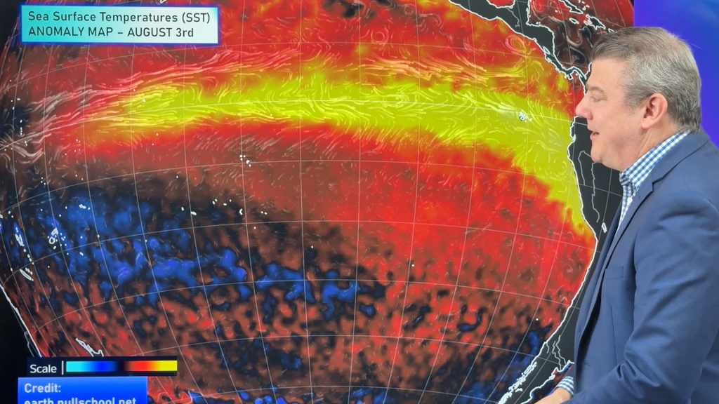
ClimateWatch: AUGUST outlook & El Niño update
El Niño continues to intensify and will do so right through to the end of our spring in NZ and…
Related Articles
Cold frosty southerly heads north, then high pressure and a weekend change
Another shot of colder air is coming for New Zealand over the next day or two, bringing frosts from the…

Cold weekend, frosts return with high pressure, then a low late next week
The subantarctic airflow spreads over NZ today/tonight and into Saturday, dropping temperatures nationwide. Snow flurries are possible today to lower…

Wintry burst of weather: Snow, squally showers then sunshine & frosts
A polar change (another one!) arrives on Friday for the South Island and goes nationwide on Saturday, leaving NZ under…

