> From the WeatherWatch archives
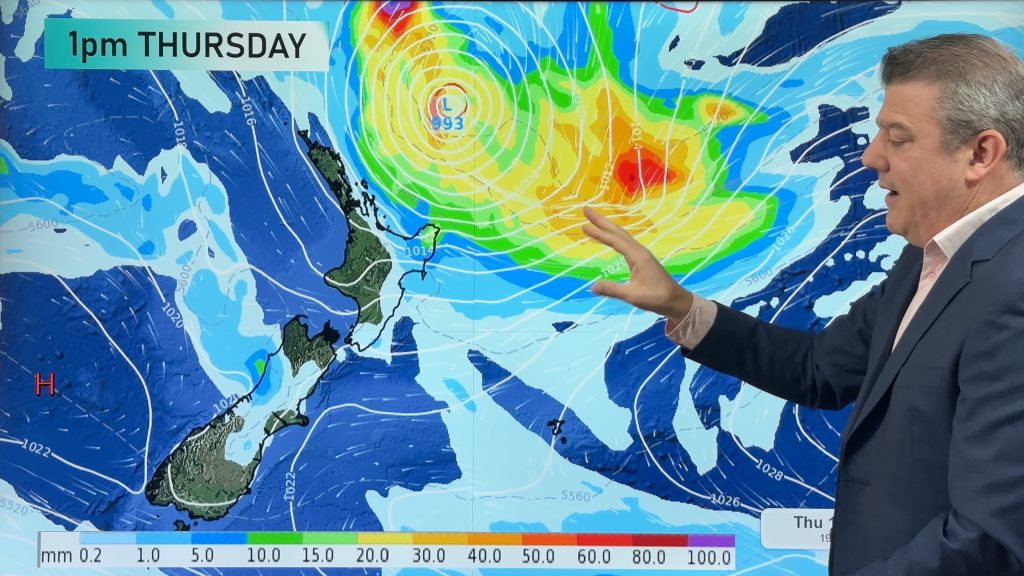
A big low pressure system in the Tasman Sea moves across New Zealand today bringing very unsettled weather to most of New Zealand. Plenty going on so check out your region below for the latest:
Northland, Auckland, Waikato & Bay Of Plenty
Becoming cloudy in the morning, rain moves in to Northland during the morning then elsewhere by midday heavy at times with possible thunderstorms and gusty northerlies. Rain eases about Northland in the afternoon then further south in the evening as winds tend gusty northwest.
Highs: 14-16
Western North Island (including Central North Island)
Cloudy with rain from afternoon, heavy about Taranaki. Northeasterlies change gusty southwest around midnight with rain easing to the odd shower.
Highs: 12-14
Eastern North Island
Some early sun then expect thickening high cloud, areas of rain move in during the afternoon possible heavy about Gisborne then easing to showers overnight as a strong southwest change moves through.
Highs: 14-15
Wellington
Becoming cloudy in the morning, rain develops in the afternoon then eases evening with a strong southerly change.
High: 12
Marlborough & Nelson
Cloudy with rain developing in the afternoon, heavy for some especially Tasman Bay then mostly clearing overnight as northerly winds change strong southerly, some snow for a time in the evening but mostly sticking above 700m before clearing.
Highs: 10-12
Canterbury
High cloud thickens in the morning, rain moves in during the afternoon as gusty southwesterly winds develop. Snow to 800m at first lowers all the way to near sea level overnight. At the point snow flurries are near sea level shower activity does ease and clears away from inland areas becoming more coastal. Heavy snow is likely for inland areas above 400 perhaps 300m today.
Highs: 7-8
West Coast
Cloudy with the odd shower possible in the morning then rain moves in by midday. Rain clearing overnight as easterlies tend gusty southeast.
Highs: 10-11
Southland & Otago
Morning rain moves in with snow lowering to 300m, rain eases to the odd wintry shower in the afternoon about Southland and by evening for Otago with snow flurries now possible to sea level although accumulations by this stage will be fairly minimal.
Highs: 4-7
By Weather Analyst Aaron Wilkinson – WeatherWatch.co.nz
Comments
Before you add a new comment, take note this story was published on 17 Jul 2015.


Add new comment
Ian on 17/07/2015 11:50pm
We just got hit by a tornado in Pearata??. It past through our fields and took out at least 9 trees and snapped others clean in half. Its a real mess the house was shacking very bad as well.
Reply
Steve on 17/07/2015 11:18pm
It has been interesting to watch the weather change this morning. Day started with 4mm overnight with light drizzle here just south of Waipu. Wind out of the north as forecast then at 10 am it shifted abruptling to the west with heavy rain and strong winds putting another 10mm into the guage within 15minutes. Now at 11.15 am weather appears to be clearing to the west with conditions almost calm. Rain radar seems to show that is it for the time being as well.
Cheer Steve
Reply