Risk of flooding, slips returns again to Nelson/Tasman region (+3 Maps)
22/09/2021 5:56am
> From the WeatherWatch archives
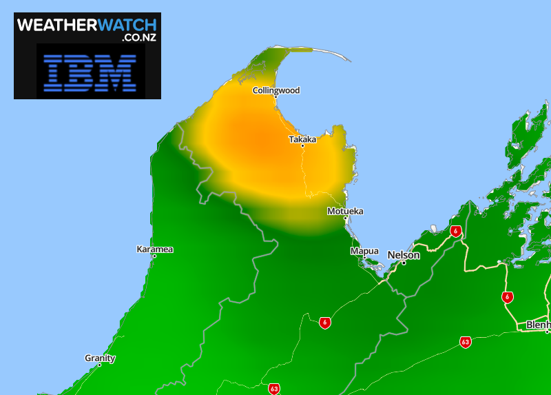
A low from the west will slowly move into NZ driving a partial sub-tropical rain flow directly into the upper South Island over the next 24 hours. The slow moving, wet, northerly will see rainfall accumulate in the Nelson/Tasman region with totals well in excess of 100mm likely in the ranges and below 100mm further east.
RuralWeather.co.nz (which has the most accurate rainfall forecasts in NZ, powered by IBM) is forecasting 100mm in the next day or two around Takaka, up to 80mm in Motueka and around 50 to 60mm in Nelson. In the Nelson Ranges up to 150mm is possible.
Rainfall at this level, in this specific part of the South Island, has a high chance of causing slips and a moderate to high risk of localised flooding, especially on the Takaka side.
Government forecaster MetService has a tax funded ‘rain watch’ for Tasman west of Motueka. “Watches” have no specific details in them other than a risk of heavy rain. A warning may be issued by them today. You can view all MetService public warnings live here.


Latest Video

More heavy rain, snow – but large dry areas, especially as we go into the long weekend
Heavy rain will continue for parts of Canterbury and Marlborough over the next day or two and it will gradually…
Related Articles
More heavy rain, snow – but large dry areas, especially as we go into the long weekend
Heavy rain will continue for parts of Canterbury and Marlborough over the next day or two and it will gradually…

Large low brings rain, downpours & some snow – gets colder as the week progresses
Low pressure will cross the upper North Island in the days ahead and that set-up actually pushes more heavy rain…

WeatherWatch App launches real-time local lightning tracker!
A bolt out of the blue! WeatherWatch has launched a live, real-time lightning tracker, enabling Kiwis to gain access to data provided by the…

