
> From the WeatherWatch archives
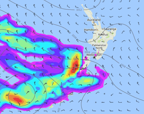
A northwesterly airflow strengthens over New Zealand from afternoon especially over the South Island with a very deep low forming in the southern Tasman Sea then moving past the lower South Island overnight.
RainWatch is a series during the weekdays, giving a snapshot about where around New Zealand areas of precipitation may affect your day.
The odd patchy shower about for the lower North Island in the west otherwise mainly dry for much of the North Island. By dawn on Thursday some rain may move in between Wellington up through to Taranaki in the west.
The West Coast of the South Island has rain all day, heavy at times with torrential falls and thunderstorms developing in the evening. Some rain for Canterbury (mainly Banks Peninsula southwards) clears in the evening for areas east of the foothills. Rain quite heavy about the high country in the evening / overnight with thunderstorms possible. Some further rain possible for the Canterbury coast overnight.
Southland and Otago see rain move in during the afternoon possibly heavy for a time evening onwards. Rain may be heaviest in the evening / overnight inland where thunderstorms are possible too.
WeatherWatch.co.nz
Image – Wednesday 4pm, 18th January 2017 rain / MSLP map – weathermap.co.nz
Latest Video

Wintry weather coming: Snow, rain, wind & sunshine
A cold front is moving into NZ from Friday to Sunday with low pressure developing west of NZ and then…
Related Articles

Polar airflow + northern low = pockets of heavy rain & snow
A colder change is coming – and so too is a large low which will develop and grow over northern…
Wintry weather coming: Snow, rain, wind & sunshine
A cold front is moving into NZ from Friday to Sunday with low pressure developing west of NZ and then…

ClimateWatch: JULY outlook & what El Niño means for NZ
El Niño is officially here and still getting stronger in the months ahead, but it’s harder to notice its effects…

