RainWatch – Rain with heavy falls for the upper North Island today
10/08/2020 7:00pm

> From the WeatherWatch archives
Mainly dry for the South Island today, just a few showers for Southland and Fiordland. As a low pressure system from the Tasman Sea moves towards the upper North Island, an associated front delivers rain spreading from the north reaching the likes of Taranaki across to Hawkes Bay this evening. Expect heavy for Northland, Auckland, Coromandel, Bay Of Plenty then overnight about East Cape / Gisborne and Hawkes Bay.
For Wednesday heavy rain about the eastern North Island eases away, rain or showers in the west eases away also. For the South Island a few drizzle patches about Southland may spread up along the east coast during the morning then drying out from afternoon. Some parts of Canterbury especially inland will stay dry all day, even the coast only has a chance of drizzle for a time.

On Thursday a few morning drizzle patches about Hawkes Bay / Gisborne clear then from afternoon there may be an isolated shower from Waikato through to Northland. Showers about Southland spread up the east coast of the South Island during the morning and early afternoon with a southerly change. Showers clear Southland in the afternoon.
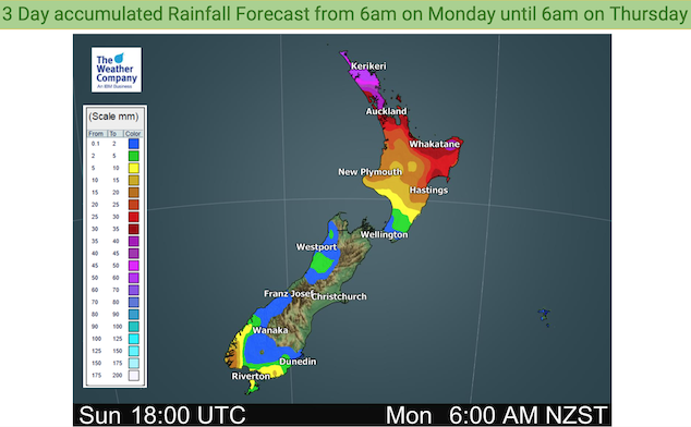
For rainfall accumulation maps for 1, 2 and 3 days out please visit our new maps page: https://www.weatherwatch.co.nz/maps-radars/rain/accumulative-rainfall
By Weather Analyst Aaron Wilkinson – WeatherWatch.co.nz
Latest Video

Antarctic southerly for parts of NZ Fri & Sat
For the first time this year a southerly from off Antarctica is heading towards the South Island, followed by more…
Related Articles
Antarctic southerly for parts of NZ Fri & Sat
For the first time this year a southerly from off Antarctica is heading towards the South Island, followed by more…

Meteors – Your Eyewitness Reports!
WeatherWatch.co.nz receives meteor reports from all over New Zealand and the globe, 24/7/365. **CASUAL COMMENTS**If you’ve seen something in the…

Snow, rain showers & cold polar southerlies set to return
Friday will be a wintry day across NZ as the next cold front arrives, bringing snow to lower levels of…

