RainWatch – Rain or showers for western regions today
29/10/2020 6:00pm

> From the WeatherWatch archives
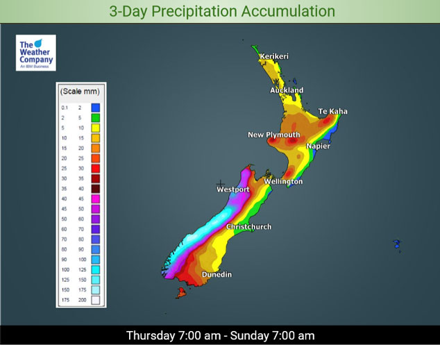
A northerly airflow lies over the country today, mainly dry in the east. Some rain for the West Coast of the South Island with a few heavy falls, mostly Greymouth southwards. Showers spread into Southland during the afternoon, clearing evening. A few spits may spread into Otago during the afternoon also, clearing evening.
Largely dry for the North Island in the morning then showers picking up in the afternoon between about Waikato and Palmerston North in the west, easing later in the evening. Mainly dry for the rest of the North Island.
Saturday sees a cold front sweep northwards over the country, heavy rain for the western South Island, perhaps a few thunderstorms north of Greymouth. Showers for the western North Island, heavy late afternoon or evening as northerlies change northwest. Mainly dry for the eastern North Island.
A cold change pushes northwards through Southland, Otago and South Canterbury in the afternoon bringing rain then easing later in the evening. There may be a thunderstorm about North Otago and South Canterbury with this change. Once the change pushes northwards into the rest of Canterbury only expect a few showers.
A southwesterly airflow brings a few showers to southern and western parts of the country on Sunday, in the east a few morning showers from Canterbury up to Wellington clear away then during the afternoon an additional shower or two pushes northwards through Otago and into South Canterbury.
For rainfall accumulation maps for 1, 2 and 3 days out please visit our new maps page: https://www.weatherwatch.co.nz/maps-radars/rain/accumulative-rainfall
By Weather Analyst Aaron Wilkinson – WeatherWatch.co.nz
Latest Video

Antarctic southerly for parts of NZ Fri & Sat
For the first time this year a southerly from off Antarctica is heading towards the South Island, followed by more…
Related Articles
Antarctic southerly for parts of NZ Fri & Sat
For the first time this year a southerly from off Antarctica is heading towards the South Island, followed by more…

Meteors – Your Eyewitness Reports!
WeatherWatch.co.nz receives meteor reports from all over New Zealand and the globe, 24/7/365. **CASUAL COMMENTS**If you’ve seen something in the…

Snow, rain showers & cold polar southerlies set to return
Friday will be a wintry day across NZ as the next cold front arrives, bringing snow to lower levels of…

