
> From the WeatherWatch archives
A low pressure system centred over the North Island and a large high in the Tasman Sea directs in a cool southerly airflow over New Zealand today.
North Island
Rain moves into the upper North Island early this morning, possibly heavy then easing to showers around midday. Showers may become heavy late afternoon / evening in the west with a chance of thunder then easing overnight. Showers for the lower western North Island, possibly heavy from afternoon then easing this evening.
Early rain eases to showers for Wairarapa, rain moves into Hawkes Bay this morning then Gisborne around midday before easing to showers this afternoon, winds from the south.
South Island
Rain or showers for Canterbury, Marlborough and Nelson easing this afternoon becoming patchy by evening with long dry spells developing. South Canterbury may have a mainly dry day after any early showers clear. The odd light shower possible from afternoon about Southland then clearing by evening.
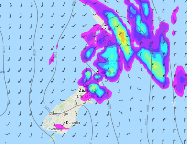
Image: Monday 14th January 2019 4:00pm MSLP / Rain map – weathermap.co.nz
WeatherWatch.co.nz
Latest Video

Cold weekend, frosts return with high pressure, then a low late next week
The subantarctic airflow spreads over NZ today/tonight and into Saturday, dropping temperatures nationwide. Snow flurries are possible today to lower…
Related Articles
Cold weekend, frosts return with high pressure, then a low late next week
The subantarctic airflow spreads over NZ today/tonight and into Saturday, dropping temperatures nationwide. Snow flurries are possible today to lower…

Wintry burst of weather: Snow, squally showers then sunshine & frosts
A polar change (another one!) arrives on Friday for the South Island and goes nationwide on Saturday, leaving NZ under…

Antarctic southerly for parts of NZ Fri & Sat
For the first time this year a southerly from off Antarctica is heading towards the South Island, followed by more…

