RainWatch – Heavy rain moves into the western South Island
21/09/2020 7:00pm

> From the WeatherWatch archives
Rain moves into Fiordland this morning then gradually pushes northwards during the day with heavy falls, reaching into North Westland overnight. Later this evening rain pushes into Southland then a few scattered falls reach Otago overnight.
Fairly dry for the North Island but a shower or two does sneak in for some spots. A shower or two can be expected for Taranaki and Kapiti, especially this morning. Then Waikato and Northland sees the chance of an isolated shower in the afternoon. Showers reappear about Taranaki and Kapiti overnight, also about western East Cape.
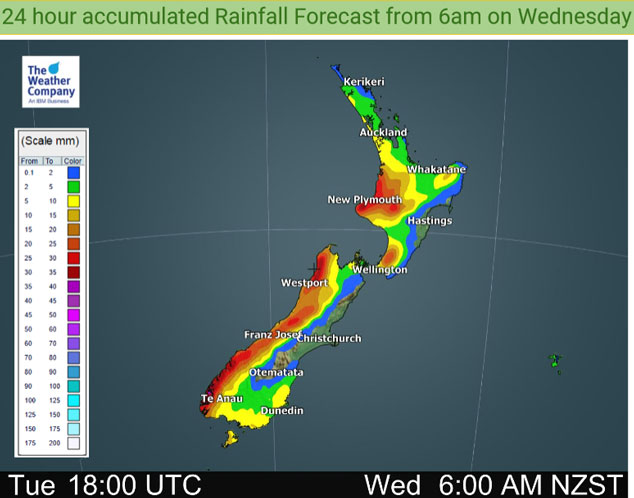
The odd shower for the western North Island on Wednesday (Waikato through to Wellington), turning to rain in the afternoon although not about Waikato till evening, this rain reaches elsewhere about the upper North Island overnight. Western East Cape catches a shower or two in a northwesterly airflow.
Heavy rain with thunderstorms eases to showers in the morning for the West Coast, morning spots of rain clear the lower South Island then from afternoon showers moves into Southland then Otago. These showers may be heavy with thunderstorms and hail then easing in the evening.
Rain or showers for much of the western North Island on Thursday including Bay Of Plenty, there may be a few heavy falls about the Waikato in the afternoon. Wellington stays largely dry all day. The east coast is mostly dry also however scattered falls spread from the west into Hawkes Bay and Gisborne in the afternoon then clearing in the evening.
Showers for the West Coast of the South Island are heavy at times with thunderstorms and hail, mainly dry in the east however once again during the afternoon showers develop for Southland and Otago, some heavy with thunderstorms and hail then clearing in the evening. An isolated shower may appear about South Canterbury and perhaps Banks Peninsula in the afternoon otherwise staying mainly dry.

For rainfall accumulation maps for 1, 2 and 3 days out please visit our new maps page: https://www.weatherwatch.co.nz/maps-radars/rain/accumulative-rainfall
By Weather Analyst Aaron Wilkinson – WeatherWatch.co.nz
Latest Video

More eastern rain, but a drier long weekend coming
Rain continues today along the eastern South Island and lower North Island, coming in from the east with heavy falls….
Related Articles
More eastern rain, but a drier long weekend coming
Rain continues today along the eastern South Island and lower North Island, coming in from the east with heavy falls….

More heavy rain, snow – but large dry areas, especially as we go into the long weekend
Heavy rain will continue for parts of Canterbury and Marlborough over the next day or two and it will gradually…

Large low brings rain, downpours & some snow – gets colder as the week progresses
Low pressure will cross the upper North Island in the days ahead and that set-up actually pushes more heavy rain…

