RainWatch – A cold front moves into the lower South Island this afternoon bringing rain
8/09/2020 5:00pm
> From the WeatherWatch archives
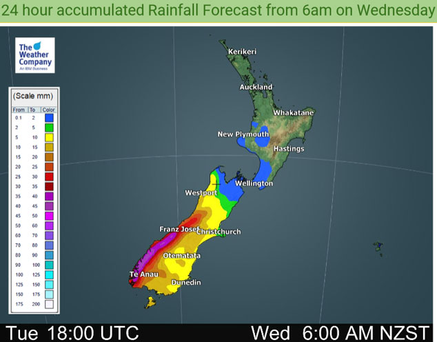
Rain moves into Southland early afternoon then Otago late afternoon with a cold southwest change, rain pushes northwards this evening / overnight reaching to about Banks Peninsula. The odd shower for the West Coast, rain moves into South Westland this afternoon with heavy falls, moving northwards this evening / overnight. Mainly dry for the North Island, a light shower or two may move in to the west Taranaki southwards from this evening.
The odd shower for the western North Island on Thursday. A southerly change pushes into the lower North Island around midday bringing a more persistent period of showers, this south to southwest change gradually moves northwards bringing a period of showers to the upper North Island (including Hawkes Bay / Gisborne) in the evening.
Rain for the upper South Island eases to showers in the afternoon, clearing in the evening on the West Coast but the odd shower remains elsewhere. Southland and Otago sees the odd shower during the day with cool southwesterlies.

Expect showers for the east coast of the North Island on Friday with cold south to southwesterly winds. Mainly dry in the west however there may be a shower or two for Northland (especially in the west). The South Island has mainly dry weather, showers about Canterbury and Marlborough clear in the afternoon.

For rainfall accumulation maps for 1, 2 and 3 days out please visit our new maps page: https://www.weatherwatch.co.nz/maps-radars/rain/accumulative-rainfall
By Weather Analyst Aaron Wilkinson – WeatherWatch.co.nz
Latest Video

More eastern rain, but a drier long weekend coming
Rain continues today along the eastern South Island and lower North Island, coming in from the east with heavy falls….
Related Articles
More eastern rain, but a drier long weekend coming
Rain continues today along the eastern South Island and lower North Island, coming in from the east with heavy falls….

More heavy rain, snow – but large dry areas, especially as we go into the long weekend
Heavy rain will continue for parts of Canterbury and Marlborough over the next day or two and it will gradually…

Large low brings rain, downpours & some snow – gets colder as the week progresses
Low pressure will cross the upper North Island in the days ahead and that set-up actually pushes more heavy rain…

