RainWatch – A cold front brings rain today south of Auckland for the NI
12/07/2020 7:00pm
> From the WeatherWatch archives
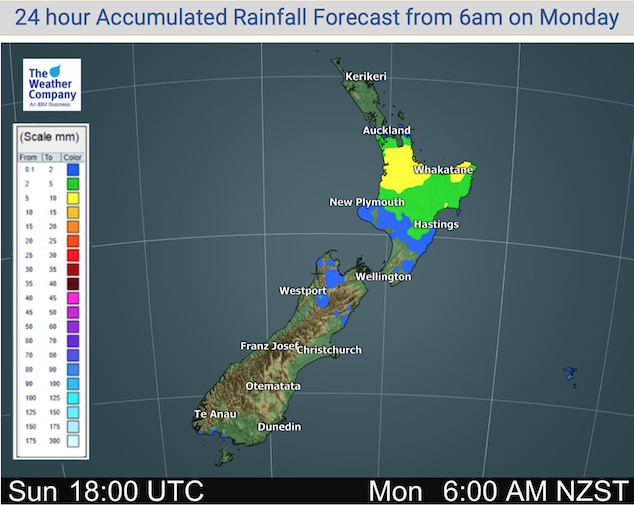
As in the title a cold front brings some rain to the North Island today south of about Auckland, rain / showers about southern parts of the North Island and the upper South Island clears this morning. Mainly dry elsewhere.
Quite dry for a majority of New Zealand on Tuesday, a light shower or two remains about the upper North Island left over from Monday’s cold front. Overnight some rain moves into some parts of the upper North Island as a warm front moves in from the Tasman Sea. Only the risk of a light shower or spit about coastal Southland during the day for the South Island.

On Wednesday a cold front moves into the upper North Island from afternoon bringing rain. Drizzle or showers move into the South Islands east coast as southerlies freshen. Rain continues for parts of the North Island on Thursday, mainly dry further south apart from the odd shower or drizzle patch north of about Banks Peninsula. Rain or showers for northern and eastern parts of the country on Friday, similar yet again through the weekend.
The rain showing below for the West Coast of the South Island is from rain that fell on Sunday, the West Coast for the week ahead is looking quite dry.

For rainfall accumulation maps for 1, 2 and 3 days out please visit our new maps page: https://www.weatherwatch.co.nz/maps-radars/rain/accumulative-rainfall
By Weather Analyst Aaron Wilkinson – WeatherWatch.co.nz
Latest Video

Antarctic southerly for parts of NZ Fri & Sat
For the first time this year a southerly from off Antarctica is heading towards the South Island, followed by more…
Related Articles
Antarctic southerly for parts of NZ Fri & Sat
For the first time this year a southerly from off Antarctica is heading towards the South Island, followed by more…

Meteors – Your Eyewitness Reports!
WeatherWatch.co.nz receives meteor reports from all over New Zealand and the globe, 24/7/365. **CASUAL COMMENTS**If you’ve seen something in the…

Snow, rain showers & cold polar southerlies set to return
Friday will be a wintry day across NZ as the next cold front arrives, bringing snow to lower levels of…

