Rain today and tonight for the dry North Island, but how much? (+Rain Map)
31/03/2019 8:00pm

> From the WeatherWatch archives
Rain is moving in to New Zealand today from both a cold front moving northwards but also the final energy left over from what was Cyclone Trevor over Queensland. It’s the best chance of rain the dry North Island has seen in some time, possibly the best chance so far this year for some.
Rainfall totals again vary with this front fairly narrow, but unlike the front last week this one may get a new burst of energy as it heads north. In recent days heavy rain fall over Queensland and this is helping feed the northern end of the front. This sub-tropical portion of air continues today then clears away later today and overnight as the cold front moves in.
This is then followed by a large high for the rest of the week although rain is likely later in the week in Fiordland while showers develop in yet another easterly flow for the North Island towards Friday and the weekend.
We’ve seen some good totals lately and more rain today will be helpful, especially the North Island. Check out the two maps below showing what has fallen and what is coming. And yes, that area in white for how much rain fell last week in the South Island indicates 200mm and above…keep in mind the totals were actually over a metre in some places there, over 1000mm!!
HOW MUCH RAIN IS COMING OVER MONDAY AND TUESDAY:
HOW MUCH RAIN FELL OVER THE PAST 7 DAYS: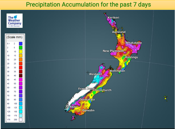
– WeatherWatch.co.nz
Latest Video

NZ: 8 Day outlook as gales & rain ease, high pressure builds
Damaging wind gusts and heavy rain will continue to affect some parts of the North Island and brushing Marlborough today…
Related Articles
NZ: 8 Day outlook as gales & rain ease, high pressure builds
Damaging wind gusts and heavy rain will continue to affect some parts of the North Island and brushing Marlborough today…

Pockets of hit & miss heavy rain, snow moves northwards
Low pressure continues to slowly move across the upper North Island and for some that will bring the sun out,…

Slow go for northern low & southern cold
For the next few days low pressure will crawl over the upper North Island, driving in rain as far south…

