Rain & Snow accumulation maps for NZ this week as rain and downpours return (+5 maps)
28/10/2018 7:54pm

> From the WeatherWatch archives
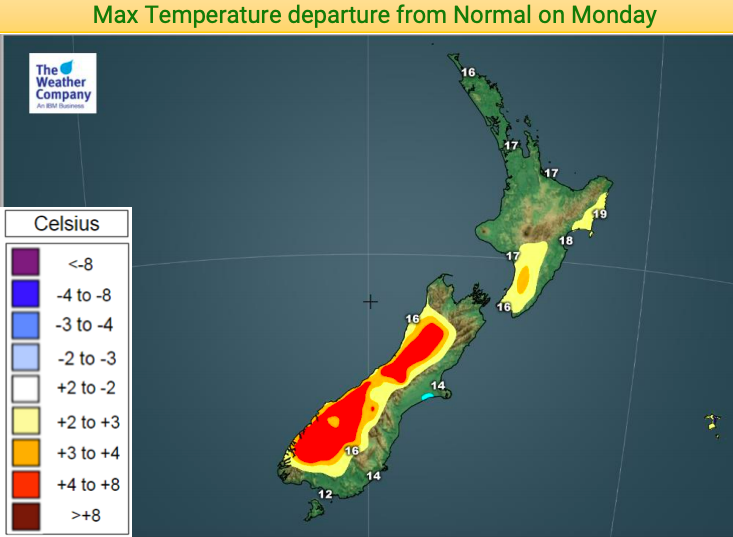
A late October surge of colder weather is on the way, peaking on Tuesday nationwide. Warmer than average weather, which has dominated a big portion of NZ this month, will give way to more normal temperatures – making it feel colder than it really is. But some regions will be briefly below average temperature-wise once this southerly kicks in.
Coldest places on Tuesday will be southern and eastern sides of the South Island and up to about Wellington/Wairarapa.
Despite the cooler air the rain will be welcome by many Farmers, Gardeners and Growers across Aotearoa. The spread of western and eastern rainfall means there is a nice even spread across both islands and across many regions. It’s not enough to reverse the drier than normal trend underway, but it is enough to be very welcome and to delay more serious drying out before summer arrives.
It’s drier than normal in Hokianga, parts of Auckland and Waikato, Hauraki Plains, parts of BOP and Hawke’s Bay, Wairarapa, Whanganui, Manawatu and parts of Canterbury. Even the West Coast is a little drier than usual (although that may change this Saturday with heavy rain forecast). Hopefully most of these regions will have 20 to 40mm of rain this week.
With colder air in the mix on Tuesday some of the rain in the South Island will fall as snow.
There are a number of sou’west cold fronts in the several days ahead: Tuesday, Thursday, Saturday night/Sunday morning and again next Tuesday.


– WeatherWatch.co.nz
Comments
Latest Video

Cold weekend, frosts return with high pressure, then a low late next week
The subantarctic airflow spreads over NZ today/tonight and into Saturday, dropping temperatures nationwide. Snow flurries are possible today to lower…
Related Articles
Cold weekend, frosts return with high pressure, then a low late next week
The subantarctic airflow spreads over NZ today/tonight and into Saturday, dropping temperatures nationwide. Snow flurries are possible today to lower…

Wintry burst of weather: Snow, squally showers then sunshine & frosts
A polar change (another one!) arrives on Friday for the South Island and goes nationwide on Saturday, leaving NZ under…

Antarctic southerly for parts of NZ Fri & Sat
For the first time this year a southerly from off Antarctica is heading towards the South Island, followed by more…


Kylie Cochrane on 29/10/2018 3:20am
Of course the weather will be wet, cold and windy the tour of southland is on and it’s very seldom fine Nd warm when it’s on.