Rain & Snow accumulation maps as belt of highs replaced with series of lows (+7 Maps)
19/11/2018 12:00am

> From the WeatherWatch archives
There is a big shift in the weather pattern around New Zealand this week and coming weekend, moving away from a big belt of dry highs to a series of large lows and rainmakers.
This week kicks off colder than average in many regions with the next couple of days fairly cool, especially in the South Island where rain will fall as snow in the mountains and ranges. Temperatures do bounce back mid week for most places, although the Deep South may remain cool all week.
A big area of low pressure is affecting New Zealand in the days ahead with the large cyclonic air flow wrapping around the entire nation by Tuesday with westerlies in Northland and easterlies in Southland – with calmer conditions in between.
The nature of this set up may be frustrating for some who need rain (especially Hawke’s Bay which is drier than average but also sheltered to some of this rain making set up, even if heavy rain may be falling just out to sea nearby). In saying that, most parts of New Zealand will get rain over the next 8 days and it should be helpful following the dry spell, which for some has lasted a couple of months now.
While conditions dry up again and warm up too for most by this Thursday and Friday yet another low moves in from Tasmania area by the weekend. This next low could bring a similar patchy set up of isolated downpours and long dry spells, then a period of rain in both islands. WeatherWatch.co.nz says this next low could impact the country from this Saturday to next Tuesday. Beyond that, in the final days of November, we may have westerlies and a few showers and another weak low (not yet locked in).
Either way, the weather pattern around New Zealand continues to be chaotic and follows a similar pattern in the south eastern corner of Australia in our view. WeatherWatch.co.nz says chaotic weather patterns are often good for New Zealand’s economy as it tends to give more variety of weather conditions, as opposed to say a strong El Nino which can deliver repetitive dry weather to the same regions week after week.
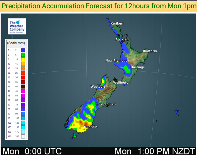
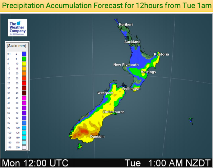

TOTAL PRECIPITATION ACCUMULATION from 1pm Monday to Tuesday 12am (35 hours)
TOTAL RAIN & SNOW ACCUMULATION OVER THE PAST 7 DAYS…


– WeatherWatch.co.nz
Latest Video

Cold weekend, frosts return with high pressure, then a low late next week
The subantarctic airflow spreads over NZ today/tonight and into Saturday, dropping temperatures nationwide. Snow flurries are possible today to lower…
Related Articles
Cold weekend, frosts return with high pressure, then a low late next week
The subantarctic airflow spreads over NZ today/tonight and into Saturday, dropping temperatures nationwide. Snow flurries are possible today to lower…

Wintry burst of weather: Snow, squally showers then sunshine & frosts
A polar change (another one!) arrives on Friday for the South Island and goes nationwide on Saturday, leaving NZ under…

Antarctic southerly for parts of NZ Fri & Sat
For the first time this year a southerly from off Antarctica is heading towards the South Island, followed by more…

