Pockets of heavy rain, large areas of dry – Your messy Queen’s Birthday Weekend forecast (+11 Maps)
3/06/2021 8:11pm

> From the WeatherWatch archives
It wouldn’t be a long weekend in New Zealand without at least a few pockets of heavy rain and strong winds – and this long weekend is no exception.
High pressure is today departing New Zealand and this marks the start of the northerly flow across the country.
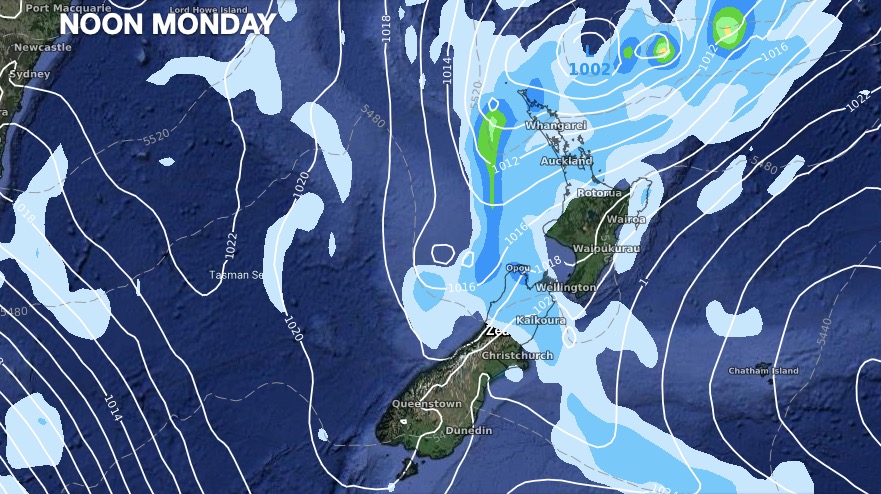
The departing high will also slow down the incoming rain bands – and while many regions have low totals, there are pockets of both islands which could get rain heavy enough to cause very localised issues. This means that some low lying areas around streams and rivers may be impacted by flooding in some places (nothing like the Canterbury floods, any potential flooding would be highly localised). The rainfall totals we are seeing aren’t extreme (and are even down a bit from yesterday’s forecast) – but with a long weekend on the way and many people outdoors we wanted to cover all bases.
The West Coast, Nelson and Northland appear to be highest candidates for these downpours – and again not everyone in those regions will have heavy rain, but these are the main risk areas where totals may get high enough to cause some isolated problems.
Over this weekend the rain clouds will only slowly move through – increasing totals for some, but this slow movement may leave other areas (like eastern and southern regions) mostly dry. There will also be large areas with just drizzly/patchy light falls and only very low rainfall accumulations.
For the most accurate rainfall forecast data in NZ please use the local WeatherWatch or RuralWeather.co.nz forecasts and keep up to date with any possible warnings that may be issued by MetService (if any, as some of these totals are on the margins of warnings). Our rainfall totals are also updated, locally, every 1 hour right across NZ, no matter where you are.
It will take until mid next week for this system to budge off the country – so expect possible changes to the forecast as this messy weather system moves through.
TO RECAP:
- A trough over the Tasman Sea is approaching the South Island Friday.
- Rain now falling across Fiordland spreads northward along
the West Coast by Saturday morning. - To the north of the trough a low pressure system will develop off the northwest of the North Island Saturday night. This low pressure and
trough will expand patchy rain across parts of the country by Sunday morning. The heaviest rain will be on the West Coast with
100-150mm of total rainfall through Sunday. - As the low will stall off the north of the North Island through early next week, the upper North Island may experience persistent
rain and gusts. - Peak northern rainfall (in both islands) will be Saturday night into Sunday with 50-80mm of rainfall across Nelson and adjoining areas
as well as Northland. This is high enough to cause pockets of localised flooding if it falls within 24 hours. - Winds will be strongest on Tuesday when over 100kmh gusts are expected across Northland coast and Great Barrier Island (not 100% locked in yet, but possible).
- Temperatures will be above to well above normal across New Zealand for the long weekend and the next several days.
- Most places DON’T have severe weather and have quite low rainfall totals, but some of our well known tourists spots (West Coast, Nelson, Northland, Coromandel Peninsula) may get some heavy rain and strong winds over the next 4 or 5 days.


Latest Video

Snow, rain showers & cold polar southerlies set to return
Friday will be a wintry day across NZ as the next cold front arrives, bringing snow to lower levels of…
Related Articles
Snow, rain showers & cold polar southerlies set to return
Friday will be a wintry day across NZ as the next cold front arrives, bringing snow to lower levels of…

Frosts, late week rain & another cold weekend coming
High pressure will cross NZ over the next few days meaning more cold nights/mornings with frosts, but a nor’wester will…

NZ: Cold & windy, then calm & frosty
Downpours, some squally with the chance of thunderstorms and even small tornadoes are possible for parts of NZ over Friday…

