Offshore storm to cross North Island today then start weakening (+11 maps)
4/01/2018 8:43pm

> From the WeatherWatch archives
UPDATED 9:43am — A storm just offshore from the western upper North Island is causing power cuts, bringing down trees and closing highways and today the low finally makes landfall and starts to slowly unravel.
As of mid-morning the centre of the low was brushing Auckland bringing rain back and strong winds, with gales – possibly damaging in the far west near the Tasman Sea for a time.
The peak of the winds is this morning and will start to ease back a little into the afternoon, but as the low tracks into land this will push windy weather into new areas.
It will be a windy day in many places with gales in a number of exposed coastal areas. More power cuts are possible across the North Island.
As of 9:30am the centre of the low could be seen on the public rain radar spinning just SW of Auckland and is tracking SE towards Taranaki/Waikato regions.
 In the WeatherWatch.co.nz infographic above, using the tax funded rain radar image note the area of rain between the centre of the low and Northland and Auckland – this is where the strongest of the winds are. These winds travel with the centre of the low and are peaking around Friday morning. As the low starts to weaken today these peak winds around the centre will start to ease back also.
The centre of the low is tracking SE towards Taranaki/Waikato/Waitomo areas – it should make ‘landfall’ somewhere in these areas this afternoon and then weaken further as it crosses land in a SE direction.
Dangerous sea and beach conditions will remain around a large portion of Friday and Saturday in both islands.
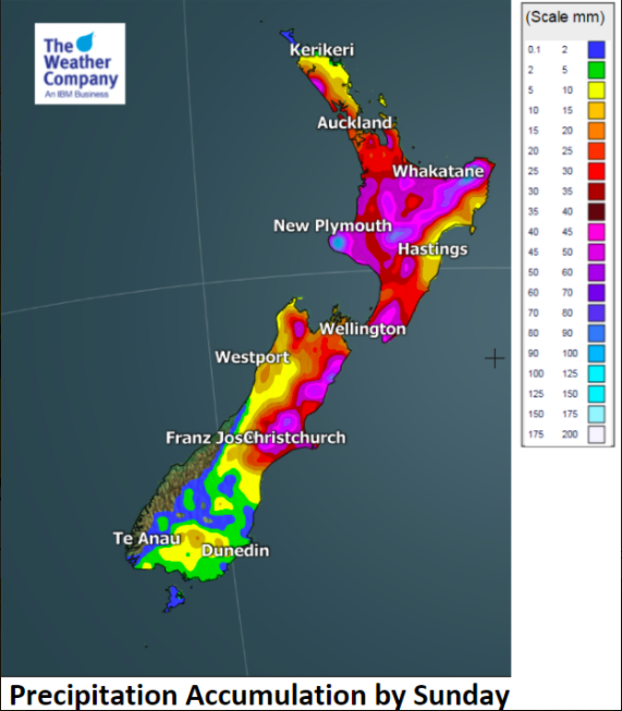
As the low tracks further south it will push heavier bands of rain into Canterbury and some other South Island areas before clearing the country over the weekend.
High pressure returns to New Zealand for the start of next week.
 KEY for WIND MAPS ABOVE:
Yellow = 30km/h. Darkest Orange up to 90km/h. Small areas in Red over 100km/h

– WeatherWatch.co.nz
Latest Video

NZ: 8 Day outlook as gales & rain ease, high pressure builds
Damaging wind gusts and heavy rain will continue to affect some parts of the North Island and brushing Marlborough today…
Related Articles
NZ: 8 Day outlook as gales & rain ease, high pressure builds
Damaging wind gusts and heavy rain will continue to affect some parts of the North Island and brushing Marlborough today…

Pockets of hit & miss heavy rain, snow moves northwards
Low pressure continues to slowly move across the upper North Island and for some that will bring the sun out,…

Slow go for northern low & southern cold
For the next few days low pressure will crawl over the upper North Island, driving in rain as far south…

