NZ (THU): Latest on Cyclone Vaianu, Sunday landfall in North Island
9/04/2026 12:21am
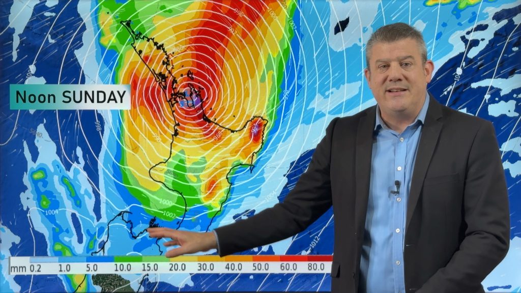
Severe weather is expected to develop as early as Saturday in the upper North Island ahead of Cyclone Vaianu, which is expected to make landfall somewhere around Auckland to Coromandel Peninsula on Sunday daytime. The cyclone is then likely to travel through the heart of the North Island come out on the eastern coastline (maybe around Hawke’s Bay) during Sunday PM – as the storm accelerates southwards.
By Monday the storm will already be south-east of Canterbury and well offshore, as it merges with a colder low pressure zone moving into the western North Island.
We break down the stages of the tropical cyclone moving in, covering wind, rain and dangerous seas. We’ll get more detailed on wind potential on either Friday or Saturday as this needs more fine tuning – but much of the North Island is exposed to wind and rain for a time, but it’s worth noting our mountain ranges interupt both airflows and rainfall totals, so precise tracking of the centre of the storm matters in order to be able to lock this in. Most modelling is in agreement about timing, intensity and tracking – so our updates over Friday, Saturday and Sunday will be able to lock in even more detail.
Keep up to date with all official warnings and watches from MetService.
Comments
Latest Video

Matariki, the long weekend + the outlook for next week
Wet weather and cloud continues along the eastern side of the country with the heaviest rain now moving into northern…
Related Articles
Matariki, the long weekend + the outlook for next week
Wet weather and cloud continues along the eastern side of the country with the heaviest rain now moving into northern…

More eastern rain, but a drier long weekend coming
Rain continues today along the eastern South Island and lower North Island, coming in from the east with heavy falls….

More heavy rain, snow – but large dry areas, especially as we go into the long weekend
Heavy rain will continue for parts of Canterbury and Marlborough over the next day or two and it will gradually…


Peter on 10/04/2026 4:33am
Not good enough!, at this stage wind speed near the center should be given and directions
Anne on 10/04/2026 1:17am
Outstandingly clear and comprehensive explanation without dumbing the content down. Thanks.
Denise on 9/04/2026 4:48pm
Very comprehensive. Thank you.
Lorretta on 9/04/2026 8:59am
Great coverage and explanation and all in English too 🙂
Greg / surfer on 9/04/2026 8:39am
This will freak-out the Greenies: 2 cyclones in ‘cyclone season’ AND a frigid snow blizzard in Tasmania on the same weekend – autumn weather will do that.
Lest we parrot NIWA/RNZ/TVNZ, the storm arriving tomorrow will be ex-TC Vaianu: ‘ex’ as in no longer exists as a cyclone, or ‘extra’ as in beyond or out of the tropics. Surf’s up!
Nick on 9/04/2026 6:29am
Great work. No flowery language as per TVNZ just plain talk.
Kaz on 9/04/2026 8:08am
Agree… factual, without the alarmist language used in the media… thank you
Peter on 9/04/2026 4:54am
A professional presentation. Not treating us like preschoolers and not describing rain coming from a squeezed sponge, or being tickled with rain.
Keith on 9/04/2026 1:50am
That is the info I was looking for. Will follow this site.
Wazza on 9/04/2026 12:49am
Thanks Phil,
Always great weather updates!
Just wondering could there be any chance that the current Highs might get larger and buffer us and move that Storm more West of us..
#BeingOptimistic.. 😅
Warm regards,
Wazza!
View more comments