NZ (SAT): Updated forecast for Cyclone Vaianu
11/04/2026 1:34am
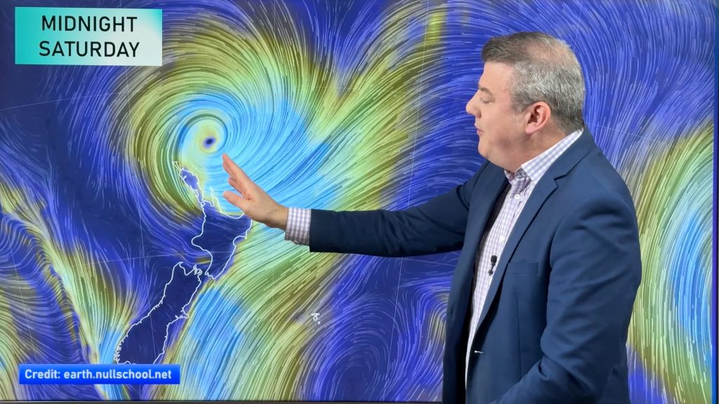
We have the latest tracking of Vaianu as the subtropical cyclone moves into the upper North Island tonight, and across the North Island on Sunday. By Monday the storm will be quickly accelerating away from New Zealand, which is better news for the country.
In today’s video we track the expected timing of the storm, which areas are most impacted by wind and rain, general rainfall totals (keep up to date with MetService warnings and watches, as they are more localised to your region) and timing of wind and wind direction changes.
New Zealand’s mountains and ranges play a huge role in breaking up severe weather – sometimes making weather more extreme in some pockets, while others may have lighter winds and limited rainfall. A slight shift in tracking can make big changes to the weather here in NZ.
Areas most exposed to wind will be the top of the North Island and eastern side down to about Manawatu and Wairarapa but windy weather could affect other parts of the island and even the upper South Island. We’ll have more details on any impact to the upper South Island in our Sunday video.
Rain will be most intense near the centre of the storm, where the air pressure is lowest, as will be some of the most damaging winds.
Cyclones can wobble as they move, and that can affect both the future tracking and weather warnings. So keep up to date with our forecasts (they update hourly) – or view RuralWeather.co.nz or download the WeatherWatch free App to better view rain and wind graphs. Monitor the MetService warnings and watches as they will be updated again today or tonight and again across Sunday.
Comments
Latest Video

Matariki, the long weekend + the outlook for next week
Wet weather and cloud continues along the eastern side of the country with the heaviest rain now moving into northern…
Related Articles
Matariki, the long weekend + the outlook for next week
Wet weather and cloud continues along the eastern side of the country with the heaviest rain now moving into northern…

More eastern rain, but a drier long weekend coming
Rain continues today along the eastern South Island and lower North Island, coming in from the east with heavy falls….

More heavy rain, snow – but large dry areas, especially as we go into the long weekend
Heavy rain will continue for parts of Canterbury and Marlborough over the next day or two and it will gradually…


Kathleen Shelley johnstone on 11/04/2026 5:33pm
I got caught in a Cyclone in Auckland. And it’s happening again. Since I moved to wellington in 2024.
Ruth on 11/04/2026 12:56pm
I hope the Cyclone leave us alone, as we are in hardship already…
Fono on 11/04/2026 7:28pm
I saw people are very nervous and panicked yesterday afternoon we went to our local supermarket and it’s like Christmas shopping long queue with full trolley one of busiest day of the week one of the worker said.This morning l woke up with my camera and my phone is fully charged and looking outside everything is calm no heavy rain no wind and praise to Jesus for loving us with a brand new Day.
Ormar on 11/04/2026 12:09pm
I just hope it passes soon without damaging our country.
We are already going thru hard times .
Be safe 🙏
Amanda on 11/04/2026 11:15am
Thank you for update
We are following.
Geoff Evans on 11/04/2026 10:12am
Clear, concise and reliable forecasts. Thank you!
Anna on 11/04/2026 11:23pm
I TRUST IN JESUS
HE WILL TAKE CARE OF THE WEATHER GODS
View more comments