
> From the WeatherWatch archives
Severe Tropical Cyclone Atu is roaring into New Zealand waters today packing sustained winds of almost 170km/h and gusts to 205km/h.
The first outer bands of the cyclone are now reaching the upper North Island as high cloud but the centre of the low remains about 900kms to the north east of Northland.
The powerful category 4 cyclone has taken a miraculous journey. Roaring into life on Saturday and within 48 hours exploding into a category 4 storm, the cyclone has so far missed all the main popular islands, despite tracking very near them.
As if trying to avoid problems for populated nations Atu is weaving around the main islands and will do so around the North Island over the next 48 hours as it quite clearly curves further east away from land, before heading more southerly after clearing East Cape.
“It’s as if Atu knows we are there and doesn’t want to cause us more problems” says head weather analyst Philip Duncan, who has been tracking the storm since it first started.
He says Atu is more powerful than Wilma, which hit Northland at Auckland Anniversary Weekend in late January. “Atu is stronger and bigger than Wilma was at this point. It’s definitely fair to say that New Zealand is getting a lucky escape from this monster cyclone as it brushes by several hundred kilometres to the east”.
Mr Duncan says if Atu had tracked further south the upper North Island would have been facing a “devastating” tropical cyclone.
The models, which WeatherWatch.co.nz use, have been picking this cyclone since Monday of last week with the predicted track of the storm hardly moving over that time.
Big seas are still predicted, with Weathermap.co.nz indicating the entire eastern coastline from Northland to Bay of Plenty, and then East Cape to Hawkes Bay, will see big seas and dangerous rips over Thursday and Friday especially.
There are currently King Tides which may also increase the chance of coastal erosion and some minor coastal flooding, says WeatherWatch.co.nz.
Atu’s air pressure remains around 940hPa.

Severe tropical cyclone Atu as of 2pm NZT Wednesday, centred 900kms NE of Northland / Google Earth
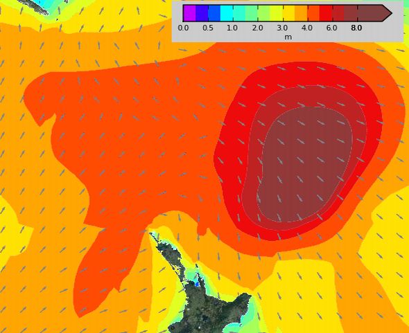
Swells at 1pm Thursday from Atu / Weathermap.co.nz

Atu’s track, weaving around all the populated places / Fiji Meteorological Service
Comments
Latest Video

Some polar airflows but more high pressure to affect NZ’s weather
Showers are in the forecast over the next several days, we track where and when they occur – but there…
Related Articles
Some polar airflows but more high pressure to affect NZ’s weather
Showers are in the forecast over the next several days, we track where and when they occur – but there…

Tracking the showers & colder changes
High pressure isn’t over NZ, but is nearby – and it’s affecting our airflows and who gets wet weather and…

Westerlies continue, sub-tropical for some
West to north-west winds blow through the South Island and lower North Island today bring heavy West Coast rain and…


Guest on 23/02/2011 3:02am
What the chance of it changing course and heading straight for us?? we don’t need two disasters in one week!!
WW Forecast Team on 23/02/2011 3:07am
I would say less than 10%. The high to the west is pushing back and the path of least resistance is over 1000kms east of NZ so it is very unlikely. Also, there is no modelling which suggests that this is even a possibility. So hopefully Atu will be a friendly giant out to the east.
– Philip Duncan
Nikki on 23/02/2011 2:12am
Farout!!! That’s def cutting it close, I’m so glad we miss out on this gigantic storm. Phew!