NZ (FRI): Latest cyclone tracking as Vaianu expected to zip over North Island
10/04/2026 12:04am
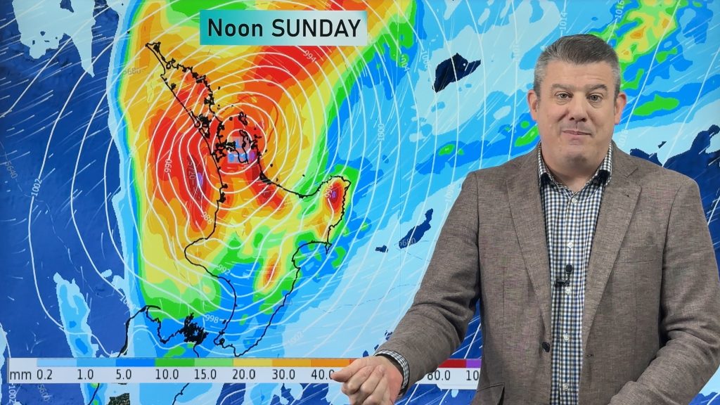
Cyclone Vaianu will cross the North Island rapidly on Sunday, making landfall somewhere around Auckland to Coromandel Peninsula during the middle of the day. Just 24 hours after that, the storm is likely to be centred south-east of Dunedin, travelling roughly the length of New Zealand in just a day.
The fast movement limits how long damaging winds can linger, and how long heavy rain falls. Some regions may have a burst of wind and rain lasting only a few hours, others may have wind and/or rain lingering for 12 to 18 hours.
Vaianu will also change shape as it moves over the North Island on Sunday PM and early Monday AM as it accelerates southwards, this alters wind and rain and how that all interacts with our mountains and ranges and makes for many moving parts, especially as winds swing around to the opposite direction behind the storm later on Sunday. So forecasts will likely change, as might some of the warnings.
Please note: The MetService warning map we show at the end of the video was updated as we were publishing this on YouTube and now shows red and orange warnings. Click here for the live map of warnings and watches: www.weatherwatch.co.nz/maps-radars/warnings/metservice
Our next video update will be on Saturday afternoon.
Comments
Latest Video

Matariki, the long weekend + the outlook for next week
Wet weather and cloud continues along the eastern side of the country with the heaviest rain now moving into northern…
Related Articles
Matariki, the long weekend + the outlook for next week
Wet weather and cloud continues along the eastern side of the country with the heaviest rain now moving into northern…

More eastern rain, but a drier long weekend coming
Rain continues today along the eastern South Island and lower North Island, coming in from the east with heavy falls….

More heavy rain, snow – but large dry areas, especially as we go into the long weekend
Heavy rain will continue for parts of Canterbury and Marlborough over the next day or two and it will gradually…


Murphy on 11/04/2026 11:21pm
It is 11:20AM in Pukekohe, it has been raining since around 11PM last night. Not much wind, still hot enough to have the AC on.
Tania on 11/04/2026 2:44pm
We are at Maketu just outta Te Puke. Both the wind and rain is here.
Jill on 12/04/2026 2:48am
Vianu just made landfall at Maketu …stay inside
Anna on 11/04/2026 12:02pm
It’s 12am here in Long Bay – lots of rain, but not much wind so far.
Diego on 11/04/2026 9:31am
It’s 9:30pm and here in Pakiri Beach are with lots of wind, around 70 Wind Gusts, a little bit of rain and 5mts waves.
The superior forces protect us!! Amem!
Steven F on 11/04/2026 8:10am
Steady rain 🌧️ here in Ranui, West Auckland since about 7:15pm. Will be keeping an eye on the situation throughout the night. 👀
Steven F on 11/04/2026 3:46pm
Steady variable rain thoughout the night. Puddles but no flooding here in Ranui. Local river is draining fine. Removed leave buildup from drain nearby, should be fine until sunrise. 🌦️
Tamara on 11/04/2026 7:17am
im in Green lane and can see a lot of clouds , but also few start , windy as always but nothing that says warnings
Michaela on 11/04/2026 5:23am
It’s 5:21pm in North Auckland and the wind is starting to whip up and sky is looking pretty gray. My barometer is slowly dropping.
Tony on 11/04/2026 3:15am
It’s noon Saturday and it’s sunny here in Glen Innes
View more comments