North Island Low: Heavy eastern rain, strong western winds (+4 Maps)
15/10/2019 7:40pm

> From the WeatherWatch archives
More heavy rain is yet to fall over already drenched parts of the eastern North Island as a low with sub-tropical connections continues to slowly grind its way across the island.
The centre of the low spent most of yesterday stuck over the top of Northland. Today it’s out over eastern Bay of Plenty and East Cape and that does two things:
- It keeps the heavy rain pushing into eastern regions south of East Cape and north of Wairarapa.
- It brings a burst of strong to gale force sou’west winds around Auckland and surrounding areas (like Port Waikato, coastal Northland and Coromandel Peninsula).
Rain will continue today and then start to ease tonight – clearing mostly by Thursday in the east and in most other places.
Winds will peak today, ease overnight and fade properly by the end of Thursday.
On Friday strong nor’westers develop around the South Island and Cook Strait – this is from another low rapidly forming in the southern Tasman Sea but quickly moves away on Saturday.
RAIN 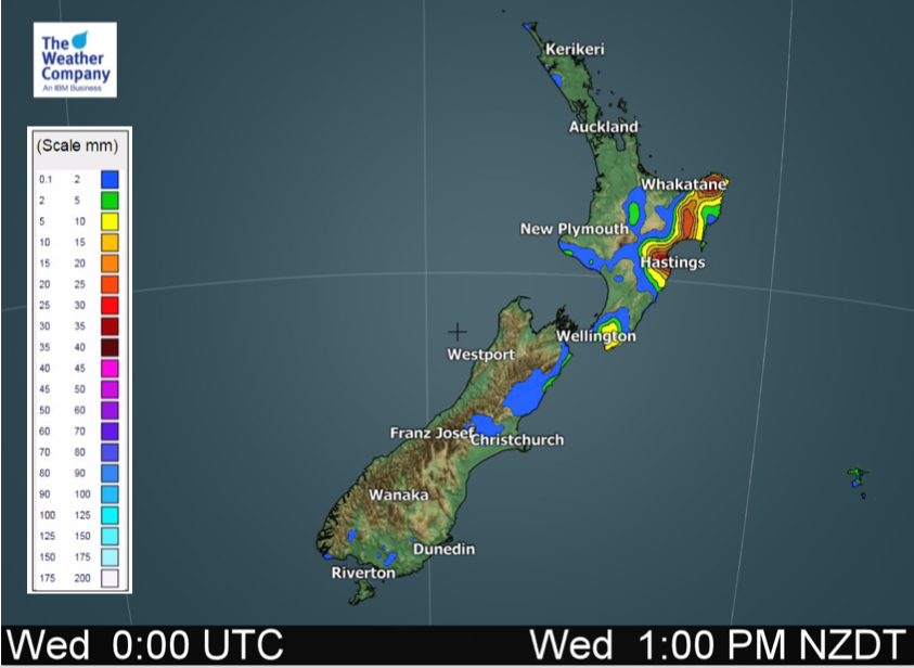 ABOVE: 12 hour expected rainfall up until 1pm today.
BELOW: 12 hour expected rainfall from 1pm today to 1am Thursday.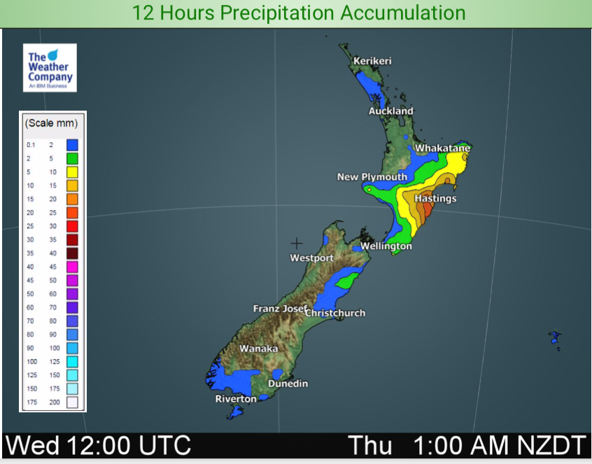
WIND:
ABOVE: Wind GUST map potential for around the middle of the day today.
BELOW: Wind GUST map for later this afternoon.
– WeatherWatch.co.nz
Latest Video

Wintry burst of weather: Snow, squally showers then sunshine & frosts
A polar change (another one!) arrives on Friday for the South Island and goes nationwide on Saturday, leaving NZ under…
Related Articles
Wintry burst of weather: Snow, squally showers then sunshine & frosts
A polar change (another one!) arrives on Friday for the South Island and goes nationwide on Saturday, leaving NZ under…

Antarctic southerly for parts of NZ Fri & Sat
For the first time this year a southerly from off Antarctica is heading towards the South Island, followed by more…

Meteors – Your Eyewitness Reports!
WeatherWatch.co.nz receives meteor reports from all over New Zealand and the globe, 24/7/365. **CASUAL COMMENTS**If you’ve seen something in the…

