
> From the WeatherWatch archives
We’re under high pressure and warmth for the next couple of days but a low in the Tasman sea will slowly approach New Zealand and by Friday will bring rain and a drop in temperatures.
The low – which is following on from Australia’s big cold change overnight – will not be overly aggressive but will tap into moisture, creating pockets of heavy rain that are slow to move along due to the big high we have just to the east. This will mostly affect the South Island’s West Coast.
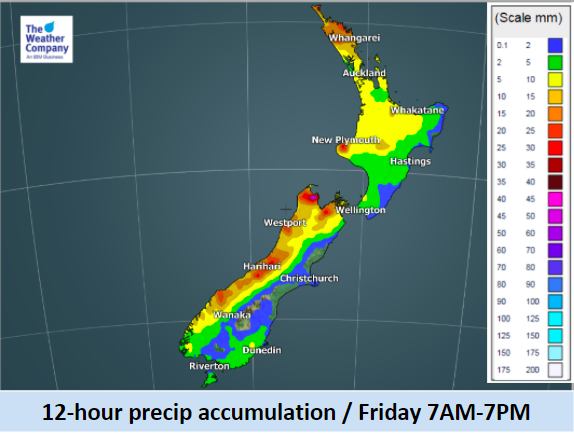
Showers will turn to rain along the entire western coastline of New Zealand on Friday – with a mix of localised heavy falls, patchy showers and drizzle patches.
Rainfall on the West Coast will start early morning Friday and persist until evening for most areas. Light to moderate rain is possible in mountainous regions overnight too. The rain accumulation for Friday daytime is estimated to be 20-30mm on the West Coast but locally heavier rainfall (enhanced by topography) is possible so trampers and farmers should be up to date with any possible state weather warnings issued by tax funded forecaster, MetService.
While Australia just saw a big temperature drop, New Zealand won’t be so dramatic. Sydney was 20 degrees cooler this morning than yesterday. By Saturday parts of Southland and Otago will be 8 to 10 degrees cooler during the day than they are today or Wednesday.

– Images / The Weather Company (An official WeatherWatch partner)
– WeatherWatch.co.nz
Latest Video

Slow go for northern low & southern cold
For the next few days low pressure will crawl over the upper North Island, driving in rain as far south…
Related Articles
Slow go for northern low & southern cold
For the next few days low pressure will crawl over the upper North Island, driving in rain as far south…

Slow moving low to track over northern NZ
A low pressure zone will slowly cross the North Island over the coming days, bringing hit and miss pockets of…

NI low pressure, SI polar change
Low pressure will move over the upper North Island this week, bringing hit and miss pockets of heavier rain into…

