Nelson: Some showers coming, but the 30 degree heat is returning too (+7 day Forecast Rainfall Map)
7/02/2019 9:52pm

> From the WeatherWatch archives
Updated 6:11pm Saturday — There is a little bit of positive news for the Nelson region – some showers are coming. This Monday night a cold front is expected to sweep up the West Coast and over the South Island bringing cooler weather behind it for a time and a burst of rain.
This rain may be heavy on the West Coast but will weaken as it crosses over the Nelson Ranges, likely turning to showers later on Monday night or Tuesday morning.
But the heat isn’t going away with the “cold front” not expected to drop temperatures much in Nelson other than while the front is over top with thick cloud cover. Once the sun returns, so too does the heat.
WeatherWatch.co.nz says by Wednesday, Thursday and Friday next week highs will again be in the late 20s and early 30s with mostly cloud-free-skies.

FORECAST TOTAL RAINFALL OVER THE NEXT 7 DAYS (To Next Friday Feb 15th):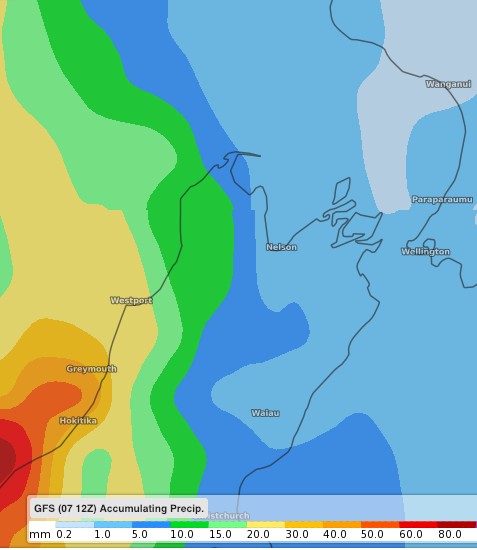
– WeatherWatch.co.nz
Latest Video

Cold weekend, frosts return with high pressure, then a low late next week
The subantarctic airflow spreads over NZ today/tonight and into Saturday, dropping temperatures nationwide. Snow flurries are possible today to lower…
Related Articles
Cold weekend, frosts return with high pressure, then a low late next week
The subantarctic airflow spreads over NZ today/tonight and into Saturday, dropping temperatures nationwide. Snow flurries are possible today to lower…

Wintry burst of weather: Snow, squally showers then sunshine & frosts
A polar change (another one!) arrives on Friday for the South Island and goes nationwide on Saturday, leaving NZ under…

Antarctic southerly for parts of NZ Fri & Sat
For the first time this year a southerly from off Antarctica is heading towards the South Island, followed by more…

