
> From the WeatherWatch archives
WeatherWatch.co.nz forecasters say the predicted possible polar blast this Sunday to Tuesday lies in the control of an extremely large high building over Australia.
The high is huge – with models predicting it will grow tall, stretching over a massive 6000kms from the tropics to Antarctica.
I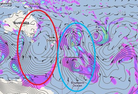 t’s the type of anticyclone that WeatherWatch.co.nz warned about a few days ago to watch out for this month and spring, while making a bold prediction that there is a “high chance” of further big snow events over the next 12 weeks.
Both WeatherWatch.co.nz and NIWA independently predicted last month that the second half of August could be more exposed to storms than the first two weeks of the month.
Image — Red zone shows the huge high stretching from Papua New Guinea to Antarctica overnight Sunday. The blue zone shows the large area of low pressure. It’s where these two zones meet that the worst of the weather will be / Weathermap.co.nz & WeatherWatch.co.nz
“This monster high over Australia and the Tasman Sea will be crucial to whether or not the snow storm hits New Zealand” says head weather analyst Philip Duncan. “We are very confident that a snow storm is brewing but still remain somewhat divided as to whether or not the bulk of the snow and wind will hit the mainland or hit further east over the Pacific Ocean and Chatham Islands”.
Mr Duncan says it all comes down to the positioning of this high. “It’s not too often you see a high stretching from Antarctica to the tropics. This is of serious concern but if the high widens – and stretches further east – it will push the snowy weather east of the country”.
He says it is far too close to populated areas to dismiss but says the models aren’t yet in full agreement.
When asked which way he thought it would go Mr Duncan said it was too early to tell. “The models are still at odds although there has been a little more consistency today that a southerly blast is likely. The question now is how much precipitation will be part of the equation”.
WeatherWatch.co.nz says the system definitely has the potential to bring snow to sea level but that the incoming high could affect the chances of snow to sea over New Zealand, indicating the majority of the energy looks as though it may be out to the east.
“The high just has to change shape in a small way and it’s the difference between a memorable snow storm and a complete non-event”.
WeatherWatch.co.nz will have extra updates over the next few days as we track all the models and likely forecasts.
– WeatherWatch.co.nz
Comments
Latest Video

Cold weekend, frosts return with high pressure, then a low late next week
The subantarctic airflow spreads over NZ today/tonight and into Saturday, dropping temperatures nationwide. Snow flurries are possible today to lower…
Related Articles
Cold weekend, frosts return with high pressure, then a low late next week
The subantarctic airflow spreads over NZ today/tonight and into Saturday, dropping temperatures nationwide. Snow flurries are possible today to lower…

Wintry burst of weather: Snow, squally showers then sunshine & frosts
A polar change (another one!) arrives on Friday for the South Island and goes nationwide on Saturday, leaving NZ under…

Antarctic southerly for parts of NZ Fri & Sat
For the first time this year a southerly from off Antarctica is heading towards the South Island, followed by more…


Matt on 11/08/2011 1:40am
I see MS are going all out in their Special Advisory
“The first big dip in temperatures will come on Saturday night when a
cold front moves onto the south of the South Island, bringing significant snow
to sea level from southern Fiordland to the Otago Peninsula. “
Leighton on 10/08/2011 11:05pm
Hi Guys
If you go to the rural forecasts and go to CHCH for example is says snow to sea level.
Cheers
Leighton
WW Forecast Team on 10/08/2011 11:43pm
Thanks for that Leighton. We’ve asked MetService why they have two different forecasts for Christchurch – one predicting rain/showers the other predicting snow to sea level. As of 11:40am we hadn’t heard back from them.
– WW