
> From the WeatherWatch archives
A ridge of high pressure lies over New Zealand on Monday morning extending out from an anticyclone to the east, as the day moves along the ridge loses its grip and a northwesterly airflow builds over the South Island.
For Northland, Auckland and Coromandel, southeasterlies tend more easterly in the afternoon. Expect a mix of sun and cloud with a shower or two moving into exposed eastern areas like eastern Northland, Great Barrier Island and eastern Coromandel. Expect mostly sunny weather in the west from Waikato down through to Wellington. A mostly cloudy day about Gisborne, perhaps even a shower or two. Hawkes Bay sees cloud break away in the afternoon, Wairarapa has morning cloud clearing to a sunny day.
Mostly sunny for the South Island however expect increasing high cloud in the east, cloud starts to thicken up along the West Coast from afternoon. A light shower or two about Fiordland spreads further north in the evening. Winds from the northeast, strong about coastal Fiordland. Winds over most of the South Island tilt more to the north or perhaps northwest later in the day / overnight.
Temperatures ranging from 10 to 14 degrees across the North Island tomorrow, the warmest highs naturally being in the far north and the coldest about Wellington and the Central Plateau. Highs ranging from 9 to 12 degrees over the South Island. The coldest highs will be about Fiordland and the southern Alps, warmest about inland Canterbury.
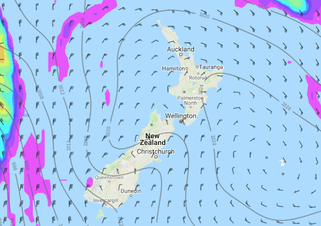
Image: Monday 19th August 3:00pm MSLP / rain map – weathermap.co.nz
WeatherWatch.co.nz
Latest Video

Cold weekend, frosts return with high pressure, then a low late next week
The subantarctic airflow spreads over NZ today/tonight and into Saturday, dropping temperatures nationwide. Snow flurries are possible today to lower…
Related Articles
Cold weekend, frosts return with high pressure, then a low late next week
The subantarctic airflow spreads over NZ today/tonight and into Saturday, dropping temperatures nationwide. Snow flurries are possible today to lower…

Wintry burst of weather: Snow, squally showers then sunshine & frosts
A polar change (another one!) arrives on Friday for the South Island and goes nationwide on Saturday, leaving NZ under…

Antarctic southerly for parts of NZ Fri & Sat
For the first time this year a southerly from off Antarctica is heading towards the South Island, followed by more…

