
> From the WeatherWatch archives
A large anticyclone controls New Zealand’s weather on Monday bringing mainly settled conditions, it is centred just out to the east so expect a northeasterly airflow over the country. Meanwhile a large area of low pressure brews in the Tasman Sea.
For most of the North Island expect a mix of sunny areas and high cloud, mid level cloud pushes into eastern Northland during the day bringing a light shower or two. The same is possible for Wairarapa and perhaps Hawkes Bay. Once again there may be some morning fog about the Waikato and other Central North Island areas.
For the South Island expect plenty of high cloud with some sun at times, areas of morning fog possible about inland areas especially Otago. Southland may experience areas of mid level cloud throughout the day, Canterbury sees some mid level cloud also mainly Banks Peninsula southwards.
Temperatures reaching into the mid to late teens along the North Island’s east coast, late teens or perhaps early twenties out west. Temperatures in the mid to late teens for most of the South Island, the warmest highs being about inland Southland, Central Otago and some parts of Buller.
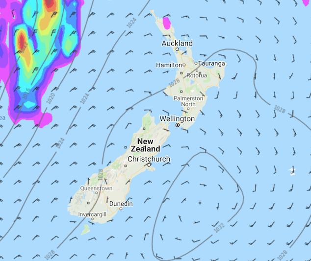
Image: Monday 6th May 2019 3:00pm MSLP / rain map – weathermap.co.nz
WeatherWatch.co.nz
Latest Video

Cold weekend, frosts return with high pressure, then a low late next week
The subantarctic airflow spreads over NZ today/tonight and into Saturday, dropping temperatures nationwide. Snow flurries are possible today to lower…
Related Articles
Cold weekend, frosts return with high pressure, then a low late next week
The subantarctic airflow spreads over NZ today/tonight and into Saturday, dropping temperatures nationwide. Snow flurries are possible today to lower…

Wintry burst of weather: Snow, squally showers then sunshine & frosts
A polar change (another one!) arrives on Friday for the South Island and goes nationwide on Saturday, leaving NZ under…

Antarctic southerly for parts of NZ Fri & Sat
For the first time this year a southerly from off Antarctica is heading towards the South Island, followed by more…

