
> From the WeatherWatch archives
A slim ridge of high pressure lies over New Zealand on Monday while a low is centred just west of the North Island during the day, this low rotates over the upper North Island later in the evening / overnight.
Mostly cloudy weather for the upper North Island, showers spread into Northland during the morning, Auckland during the afternoon and perhaps a shower or two may make it into Waikato and Bay Of Plenty in the evening. Winds are light then tending to the east and freshening.
The lower North Island has a fairly settled day although there will be some cloud about Taranaki for most of the day bringing the possibility of a light shower or two. Morning mid level cloud then some afternoon sun / high cloud for the Manawatu, Wellngton and Wairarapa. Also watch for morning fog patches about some inland areas. Overnight cloud thickens up along the east coast.
A mostly cloudy start for the West Coast, sun starts to break through during the morning for North Westland although there will be some high cloud about also. Showers Greymouth southwards gradually ease and clear during the day with the last showers clearing away in the evening. Nelson down through to about Banks Peninsula in the east has a mostly sunny day with some high cloud, Banks Penisnula southwards through to Southland has cloudier weather. A shower or two about Central Otago eases and then may spread into Southland for a time.
The warmest temperatures on Monday will be about Bay Of Plenty (mainly inland) and also inland Buller with temperatures getting into the high teens.
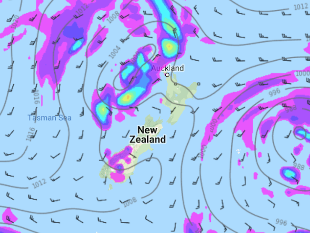
Image: Monday 10th September 2018 3:00pm MSLP / Rain map – weathermap.co.nz
WeatherWatch.co.nz
Latest Video

Cold weekend, frosts return with high pressure, then a low late next week
The subantarctic airflow spreads over NZ today/tonight and into Saturday, dropping temperatures nationwide. Snow flurries are possible today to lower…
Related Articles
Cold weekend, frosts return with high pressure, then a low late next week
The subantarctic airflow spreads over NZ today/tonight and into Saturday, dropping temperatures nationwide. Snow flurries are possible today to lower…

Wintry burst of weather: Snow, squally showers then sunshine & frosts
A polar change (another one!) arrives on Friday for the South Island and goes nationwide on Saturday, leaving NZ under…

Antarctic southerly for parts of NZ Fri & Sat
For the first time this year a southerly from off Antarctica is heading towards the South Island, followed by more…

