
> From the WeatherWatch archives
A big low pressure system moves out of the Tasman Sea on Monday with its centre passing over central New Zealand later in the afternoon / evening. This low will usher in southerlies over the South Island and a northwest airflow for the North Island.
Expect a wet day for the upper North Island with showery conditions, rain moves through in the afternoon about Auckland southwards as northerly winds tend gusty northwest. Rain eases by evening.
For the lower North Island expect areas of rain with a few heavy falls, especially about Taranaki where thunderstorms are likely. Northerly quarter winds give way to the south later in the day.
A few showers about Nelson and Marlborough turn to rain in the afternoon, heavy falls look likely then easing in the evening as southerlies freshen. The West Coast sees a shower or two, clearing in the morning then some sun breaks through. A few areas of morning fog or low cloud possible again in the east then as southerly winds pick up from afternoon a few patchy showers move in becoming more widespread by evening. Snow will most likely stay above 700m.
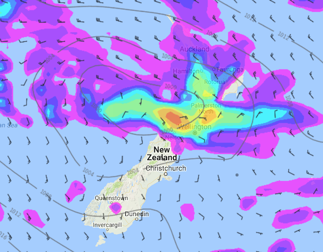
Image: Monday 18th June 2018 3:00pm MSLP / Rain map – weathermap.co.nz
WeatherWatch.co.nz
Latest Video

Cold weekend, frosts return with high pressure, then a low late next week
The subantarctic airflow spreads over NZ today/tonight and into Saturday, dropping temperatures nationwide. Snow flurries are possible today to lower…
Related Articles
Cold weekend, frosts return with high pressure, then a low late next week
The subantarctic airflow spreads over NZ today/tonight and into Saturday, dropping temperatures nationwide. Snow flurries are possible today to lower…

Wintry burst of weather: Snow, squally showers then sunshine & frosts
A polar change (another one!) arrives on Friday for the South Island and goes nationwide on Saturday, leaving NZ under…

Antarctic southerly for parts of NZ Fri & Sat
For the first time this year a southerly from off Antarctica is heading towards the South Island, followed by more…

