
> From the WeatherWatch archives
A large high slips eastwards south of New Zealand on Monday while a deepening low moves towards the North Island during the day.
For the upper North Island expect a cloudy day, there may be a shower or two about, more so from afternoon then rain develops in the evening. This area of rain may be heavy, especially overnight. It’s also quite a narrow area of heavy rain so it may only affect a certain part of the upper North Island. At this stage it’s looking to be Coromandel, Great Barrier Island and Auckland however parts of northern Waikato and northern Bay Of Plenty may see some heavy rain also. Winds from the southeast, perhaps rising to gale in the evening about some exposed eastern coastlines.
For the lower North Island expect southeasterly winds also, freshening in the evening. Cloud thickens about Wellington and along the east coast with patchy showers or drizzle to develop in the morning then rain moves into Gisborne during the afternoon with heavy falls by evening. Dry out west with plenty of high cloud, a few showers or spots of rain may develop later in the evening.
Expect cloudy weather from about Otago Peninsula through to Marlborough with some drizzle or perhaps a few areas of rain, winds from the southeast. Nelson sees some morning sun then cloud thickens up in the afternoon. Southland and other parts of Otago see morning cloud break to a few sunny spells. The West Coast has a dry day with some high cloud and mild temperatures.
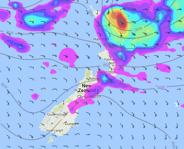
Image: Monday 11th June 2018 3:00pm MSLP / rain map – weathermap.co.nz
By Weather Analyst Aaron Wilkinson – WeatherWatch.co.nz
Latest Video

Cold weekend, frosts return with high pressure, then a low late next week
The subantarctic airflow spreads over NZ today/tonight and into Saturday, dropping temperatures nationwide. Snow flurries are possible today to lower…
Related Articles
Cold weekend, frosts return with high pressure, then a low late next week
The subantarctic airflow spreads over NZ today/tonight and into Saturday, dropping temperatures nationwide. Snow flurries are possible today to lower…

Wintry burst of weather: Snow, squally showers then sunshine & frosts
A polar change (another one!) arrives on Friday for the South Island and goes nationwide on Saturday, leaving NZ under…

Antarctic southerly for parts of NZ Fri & Sat
For the first time this year a southerly from off Antarctica is heading towards the South Island, followed by more…

