Monday’s national forecast – Front moves onto the South Island (+10 maps)
14/03/2021 3:00pm

> From the WeatherWatch archives
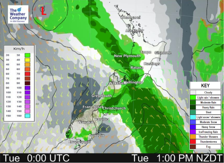
The North Island is mainly settled today due to a ridge of high pressure, a front pushes northwards over the South Island.
North Island
A mix of sun and cloud for most North Island regions today, there could be a few showers in the northeast (East Cape through to Northland) this morning about coastal parts then popping up this afternoon further inland before clearing this evening.
South Island
Heavy rain moves into South Westland this morning then moves further north this afternoon / evening. Conditions clear up this evening about South Westland but overnight further rain moves into Fiordland. Dry for Nelson down through to Canterbury in the east with high cloud and northerlies, some rain moves into Southland and Otago this afternoon then clears this evening. Overnight further rain or showers moves into the lower South Island as a cold front moves in.


Latest Video

More eastern rain, but a drier long weekend coming
Rain continues today along the eastern South Island and lower North Island, coming in from the east with heavy falls….
Related Articles
More eastern rain, but a drier long weekend coming
Rain continues today along the eastern South Island and lower North Island, coming in from the east with heavy falls….

More heavy rain, snow – but large dry areas, especially as we go into the long weekend
Heavy rain will continue for parts of Canterbury and Marlborough over the next day or two and it will gradually…

Large low brings rain, downpours & some snow – gets colder as the week progresses
Low pressure will cross the upper North Island in the days ahead and that set-up actually pushes more heavy rain…

