
> From the WeatherWatch archives
Updated 9:09am — The large low pressure system over New Zealand at the moment is so large it would also engulf the entire country of Australia and is creating crazy temperatures in New Zealand this morning.
As of 9am it was 16 degrees in Auckland and -4 in parts of Dunedin – a massive 20 degree difference.
While bigger lows don’t always mean more aggressive (as the energy is spread over a much large area) it does explain why the nation is experiencing scattered rough weather and why this has been going on for five days now – and why there are large areas of calm that can create sunny weather or frosts overnight.
On Thursday the low weakens and by Friday it’s gone to our east – as another low forms to our west (just SE of Sydney) and 24 hours after that may also be getting close to the size of Australia as it tracks towards us.
Big lows have bigger reach – in other words they can scoop up more air from the north or south of us which can encourage bigger temperatures changes (creating thunder, warmth and snow all in a week). Big lows can also have large areas of dry, calm, sunny, weather in the middle too.
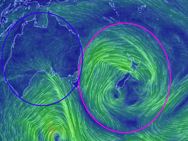
See the fully animated wind map from Earth.nullschool here.
– WeatherWatch.co.nz
Latest Video

Cold weekend, frosts return with high pressure, then a low late next week
The subantarctic airflow spreads over NZ today/tonight and into Saturday, dropping temperatures nationwide. Snow flurries are possible today to lower…
Related Articles
Cold weekend, frosts return with high pressure, then a low late next week
The subantarctic airflow spreads over NZ today/tonight and into Saturday, dropping temperatures nationwide. Snow flurries are possible today to lower…

Wintry burst of weather: Snow, squally showers then sunshine & frosts
A polar change (another one!) arrives on Friday for the South Island and goes nationwide on Saturday, leaving NZ under…

Antarctic southerly for parts of NZ Fri & Sat
For the first time this year a southerly from off Antarctica is heading towards the South Island, followed by more…

