
> From the WeatherWatch archives
Updated 1pm — A few light showers are popping up around Auckland, Coromandel Peninsula and north Waikato as we head through Saturday afternoon while the main rain band out in the Tasman Sea is brushing Nelson where heavy falls are possible later today.
As we go through Saturday the upper North Island will be mainly cloudy but also mainly dry, despite the few downpours moving through.
Drizzle and low cloud is affecting Hawke’s Bay also Christchurch.
The concern for heavy rain will be around central New Zealand, mainly the western side of Cook Strait and therefore places like the Nelson region may be in for some localised heavy falls. Regions that border Cook Strait will also be more exposed to rain later today.
On Sunday the low will drift further across the North Island with a mixture of drizzle, dry spells and downpours.
There may be slow moving downpours for the upper half of the North Island later on Sunday, or overnight Sunday and into Monday morning. Today should be mostly dry though.
The good news is that the downpours are unlikely to be as intense as what we saw a couple weeks ago with the ‘Tasman Tempest’. But, the areas of rain around this fairly weak but large low are worth monitoring – the connection to the sub-tropics and the slow moving nature of this low means areas already hit by flooding are at some risk of seeing heavy downpours over the coming days.
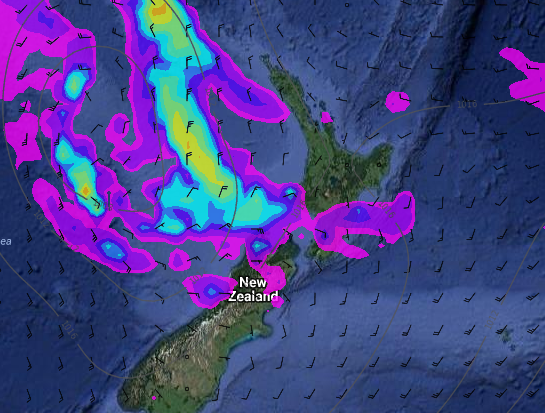
– Current Saturday morning forecast rain map / Weathermap
– WeatherWatch.co.nz
Latest Video

Wintry weather coming: Snow, rain, wind & sunshine
A cold front is moving into NZ from Friday to Sunday with low pressure developing west of NZ and then…
Related Articles

Polar airflow + northern low = pockets of heavy rain & snow
A colder change is coming – and so too is a large low which will develop and grow over northern…
Wintry weather coming: Snow, rain, wind & sunshine
A cold front is moving into NZ from Friday to Sunday with low pressure developing west of NZ and then…

ClimateWatch: JULY outlook & what El Niño means for NZ
El Niño is officially here and still getting stronger in the months ahead, but it’s harder to notice its effects…

