Long Weekend Update: Tracking the wet weather from Friday to Monday (+5 Maps)
4/02/2016 12:57am

> From the WeatherWatch archives
A large but fairly weak low lies in the northern Tasman Sea, and is being fed by a sub-tropical air flow.
Air pressure levels around New Zealand are fairly high despite this incoming front and low – which means the rain won’t spread to many places, and even though there are pockets of tropical downpours here and there the front is breaking up and weakening as it pushes into the North Island over Friday and Saturday.
The front will bring a mix of light rain, showers and drizzle – with isolated heavy sub-tropical downpours, especially overnight. Many of these downpours will be out at sea around northern New Zealand – but may affect popular northern holiday spots and main centres for a time. But the Coromandel and Kaimai Ranges may help keep western areas drier due to the easterly flow.
FRIDAY
By Friday afternoon the front will be moving down the western North Island bringing patchy rain into Northland and eventually Waikato and Coromandel Peninsula, then other regions like Waikato, Bay of Plenty and Taranaki. Some of these places may only have a few showers – but isolated downpours are possible here and there overnight.
SATURDAY
In the early hours of Saturday morning we may see a ‘flare up’ in rain activity over Northland and out into the Hauraki Gulf – and while it’s patchy and quite unpredictable it appears Northland is most exposed to isolated heavy downpours on Saturday morning.
Auckland and Coromandel Peninsula may also see rain – or showers – across Saturday with a mix of light falls, dry areas and heavy downpours. It’s a tricky one to lock in as the area of downpours is pretty small in comparison to the upper North Island.
While the chance of precipitation is very high for Auckland and Coromandel Peninsula on Saturday, at 90%, both of these regions are on the edge of this rain band and, in fact, the easterly flow may mean big portions of Auckland and Coromandel Peninsula may be dry – but it depends a lot on the angle of flow coming in to these regions at the time, and just how far south the front actually makes it before falling apart completely.
While there is a risk of rain setting in, the data supports patches of rain or showers and big areas of dry forming on the southern edge – towards south Auckland, Waikato and Bay of Plenty on Saturday.
From Waikato southwards New Zealand will be dry or mainly dry (chance of a shower in Gisborne and Hawkes Bay) across the entire long weekend.
SUNDAY
Showers will continue in eastern Northland on Sunday morning, but will mostly clear.
Sunday is a mainly dry day across New Zealand.
MONDAY
Monday is also dry with the risk of a shower or two in the Bay of Islands, Gisborne, and perhaps an isolated shower or two about the Southern Alps in the afternoon.
– WeatherWatch.co.nz
FRIDAY 1pm
Friday 1pm shows the main rain band still out at sea but patchy rain spreading south over Northland and showers moving into Auckland and Coromandel Peninsula, before turning to patchy rain later (isolated heavy falls later, mostly out at sea).
Saturday 1pm
Saturday gets a bit more complicated with the front weakening but also new downpours being triggered later into the afternoon. Most of NZ dry but Coromandel Peninsula, southern and eastern parts of Northland and northern parts of Auckland are most exposed to any downpours.
A closer look at Saturday afternoon:
If this rain map proves to be accurate it indicates many parts of Waikato and Auckland will actually be dry on Saturday with showers, and downpours most likely around Coromandel Peninsula, Great Barrier Island and perhaps northern Auckland/southern Northland to the east. Areas in pink shading are low risk of precipitation or light showers/drizzle.
Sunday 1pm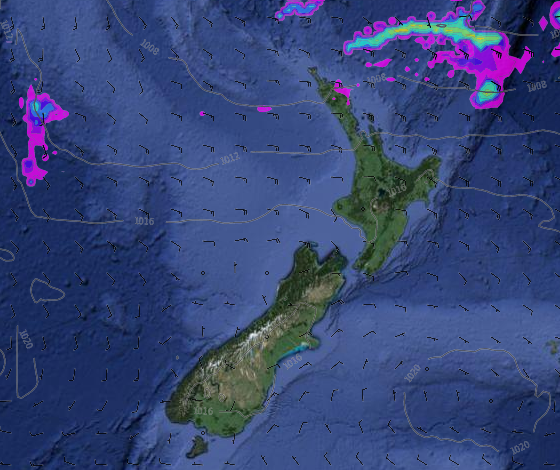
Showers remain in Northland to the east but becoming mostly dry. Dry elsewhere.
1pm Monday
A few showers possible in the Bay of Islands and around Gisborne – but should be mostly dry. Dry elsewhere.
View all the rain maps across this long weekend here
– WeatherWatch.co.nz
Latest Video

Cold weekend, frosts return with high pressure, then a low late next week
The subantarctic airflow spreads over NZ today/tonight and into Saturday, dropping temperatures nationwide. Snow flurries are possible today to lower…
Related Articles
Cold weekend, frosts return with high pressure, then a low late next week
The subantarctic airflow spreads over NZ today/tonight and into Saturday, dropping temperatures nationwide. Snow flurries are possible today to lower…

Wintry burst of weather: Snow, squally showers then sunshine & frosts
A polar change (another one!) arrives on Friday for the South Island and goes nationwide on Saturday, leaving NZ under…

Antarctic southerly for parts of NZ Fri & Sat
For the first time this year a southerly from off Antarctica is heading towards the South Island, followed by more…

