Latest Maps (x3): Rainfall, Snowfall and peak Wave Heights
17/05/2019 11:43pm

> From the WeatherWatch archives
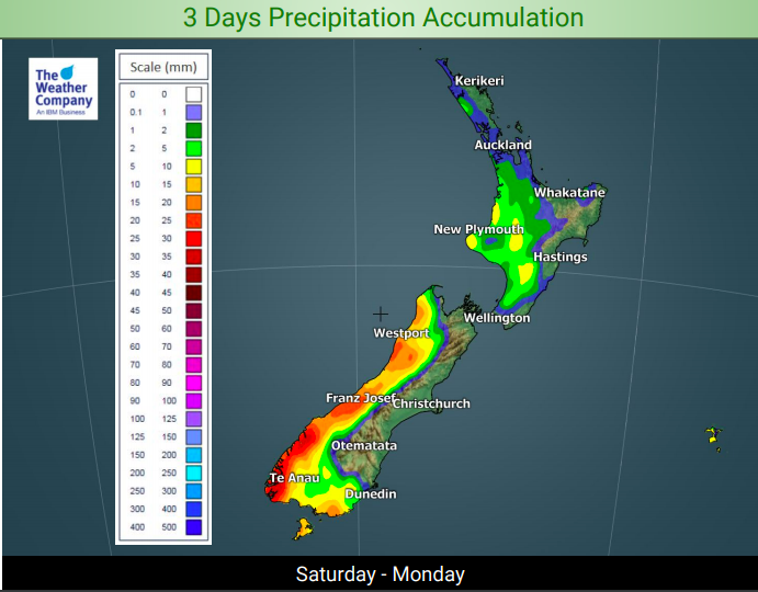
A windier south west flow around New Zealand will whip up some big waves, push more rain on to the wet West Coast and bring a dusting of snow to the mountains.
The angle of the wind flow means the bulk of the precipitation (both rain and snow) will be in the South Island with rain on the West Coast and snow in the Southern Alps.
In the North Island only showers are coming through and with stronger winds these showers won’t linger long, hence the lower rainfall totals there.
Dangerous waves are also impacting the country as we go through Sunday and Monday – not good days to be on the water with not only large waves in many places but also gale force winds in marine areas too until later on Monday.


– WeatherWatch.co.nz
Latest Video
ClimateWatch: AUGUST outlook & El Niño update
El Niño continues to intensify and will do so right through to the end of our spring in NZ and…
Related Articles
ClimateWatch: AUGUST outlook & El Niño update
El Niño continues to intensify and will do so right through to the end of our spring in NZ and…
Cold frosty southerly heads north, then high pressure and a weekend change
Another shot of colder air is coming for New Zealand over the next day or two, bringing frosts from the…

Cold weekend, frosts return with high pressure, then a low late next week
The subantarctic airflow spreads over NZ today/tonight and into Saturday, dropping temperatures nationwide. Snow flurries are possible today to lower…

