> From the WeatherWatch archives
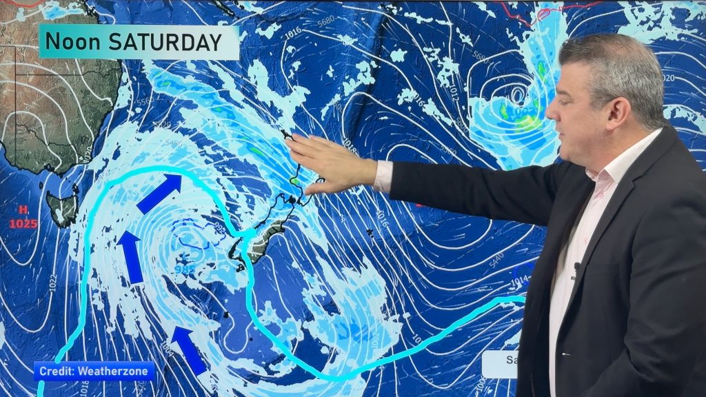
The crown forecaster issued 21 warnings Thursday evening as a severe storm roars through the Southern Ocean.
Here are all the warnings, in their entirity, as of 9pm Thursday.
Please note this page will not be updated – this is a snap shot of the warnings as of 9pm.
Northland
Strong Wind Warning, Areas Affected: The northern half of the North Island from Northland to Taranaki and across to Bay of Plenty and Taupo Northwest winds are expectd to rise to gale force in many areas Friday afternoon and then turn westerly in the evening. Between about 3pm Friday and 3am Saturday expect wind gusts 120 km/h at times, especially in squally thunderstorms.
Issued: 8:08 pm 16 Sep 2010 NZST
Auckland
Strong Wind Warning, Areas Affected: The northern half of the North Island from Northland to Taranaki and across to Bay of Plenty and Taupo Northwest winds are expectd to rise to gale force in many areas Friday afternoon and then turn westerly in the evening. Between about 3pm Friday and 3am Saturday expect wind gusts 120 km/h at times, especially in squally thunderstorms.
Issued: 8:08 pm 16 Sep 2010 NZST
Waikato
Strong Wind Warning, Areas Affected: The northern half of the North Island from Northland to Taranaki and across to Bay of Plenty and Taupo Northwest winds are expectd to rise to gale force in many areas Friday afternoon and then turn westerly in the evening. Between about 3pm Friday and 3am Saturday expect wind gusts 120 km/h at times, especially in squally thunderstorms.
Issued: 8:08 pm 16 Sep 2010 NZST
Waitomo
Strong Wind Warning, Areas Affected: The northern half of the North Island from Northland to Taranaki and across to Bay of Plenty and Taupo Northwest winds are expectd to rise to gale force in many areas Friday afternoon and then turn westerly in the evening. Between about 3pm Friday and 3am Saturday expect wind gusts 120 km/h at times, especially in squally thunderstorms.
Issued: 8:08 pm 16 Sep 2010 NZST
Coromandel
Strong Wind Warning, Areas Affected: The northern half of the North Island from Northland to Taranaki and across to Bay of Plenty and Taupo Northwest winds are expectd to rise to gale force in many areas Friday afternoon and then turn westerly in the evening. Between about 3pm Friday and 3am Saturday expect wind gusts 120 km/h at times, especially in squally thunderstorms.
Issued: 8:08 pm 16 Sep 2010 NZST
Bay Of Plenty
Strong Wind Warning, Areas Affected: The northern half of the North Island from Northland to Taranaki and across to Bay of Plenty and Taupo Northwest winds are expectd to rise to gale force in many areas Friday afternoon and then turn westerly in the evening. Between about 3pm Friday and 3am Saturday expect wind gusts 120 km/h at times, especially in squally thunderstorms. Heavy Rain Cancellation: Eastern Bay of Plenty rangesHeavy rain has now finished
Issued: 8:08 pm 16 Sep 2010 NZST
Taumarunui
Strong Wind Warning, Areas Affected: The northern half of the North Island from Northland to Taranaki and across to Bay of Plenty and Taupo Northwest winds are expectd to rise to gale force in many areas Friday afternoon and then turn westerly in the evening. Between about 3pm Friday and 3am Saturday expect wind gusts 120 km/h at times, especially in squally thunderstorms.
Issued: 8:08 pm 16 Sep 2010 NZST
Rotorua
Strong Wind Warning, Areas Affected: The northern half of the North Island from Northland to Taranaki and across to Bay of Plenty and Taupo Northwest winds are expectd to rise to gale force in many areas Friday afternoon and then turn westerly in the evening. Between about 3pm Friday and 3am Saturday expect wind gusts 120 km/h at times, especially in squally thunderstorms. Heavy Rain Cancellation: Eastern Bay of Plenty rangesHeavy rain has now finished
Issued: 8:08 pm 16 Sep 2010 NZST
Taupo
Strong Wind Warning, Areas Affected: The northern half of the North Island from Northland to Taranaki and across to Bay of Plenty and Taupo Northwest winds are expectd to rise to gale force in many areas Friday afternoon and then turn westerly in the evening. Between about 3pm Friday and 3am Saturday expect wind gusts 120 km/h at times, especially in squally thunderstorms.
Issued: 8:08 pm 16 Sep 2010 NZST
Tongariro
No warning in force for this location
Taihape
No warning in force for this location
Gisborne
No warning in force for this location
Hawkes Bay
No warning in force for this location
Wairarapa
Strong Wind Warning, Areas Affected: Wellington Wairarapa and the Marlborough Sounds Northwesterly winds are expected to rise to gale Friday morning with severe gale gusts for a time during Friday. In the 12 hour period from 6am to 6pm Friday, northwesterly gusts of 120 km/h are likely in exposed places.
Issued: 8:08 pm 16 Sep 2010 NZST
Taranaki
Strong Wind Warning, Areas Affected: The northern half of the North Island from Northland to Taranaki and across to Bay of Plenty and Taupo Northwest winds are expectd to rise to gale force in many areas Friday afternoon and then turn westerly in the evening. Between about 3pm Friday and 3am Saturday expect wind gusts 120 km/h at times, especially in squally thunderstorms.
Issued: 8:08 pm 16 Sep 2010 NZST
Wanganui
No warning in force for this location
Manawatu
No warning in force for this location
Horowhenua
No warning in force for this location
Wellington
Strong Wind Warning, Areas Affected: Wellington Wairarapa and the Marlborough Sounds Northwesterly winds are expected to rise to gale Friday morning with severe gale gusts for a time during Friday. In the 12 hour period from 6am to 6pm Friday, northwesterly gusts of 120 km/h are likely in exposed places.
Issued: 8:08 pm 16 Sep 2010 NZST
Marlborough
Strong Wind Warning, Areas Affected: Wellington Wairarapa and the Marlborough Sounds Northwesterly winds are expected to rise to gale Friday morning with severe gale gusts for a time during Friday. In the 12 hour period from 6am to 6pm Friday, northwesterly gusts of 120 km/h are likely in exposed places.
Issued: 8:08 pm 16 Sep 2010 NZST
Nelson
No warning in force for this location
Nelson Lakes
No warning in force for this location
Buller
No warning in force for this location
Westland
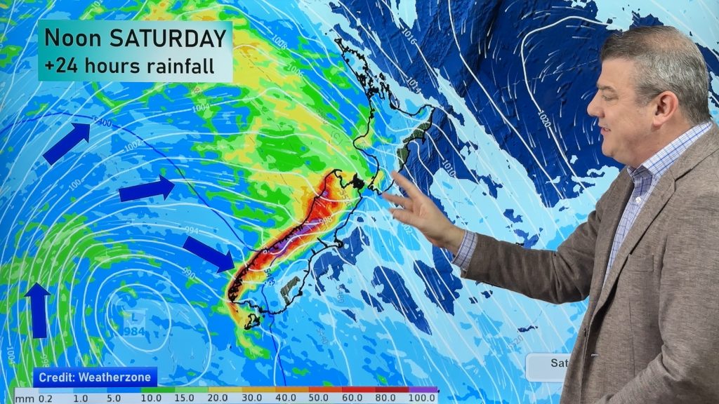
Heavy Rain Warning, Areas Affected: Westland ranges south of Otira Periods of heavy rain are expected during Thursday night and Friday. In the 28 hours from 8pm Thursday to midnight Friday, 100 to 140mm of rain is likely. During the same period 40 to 60mm could fall in lowlying coastal areas. Rainfall intensities may reach 15 to 20mm per hour at times. Note: Snow levels are expectd to lower to 300 or 400 metres during Friday and there is heavy snow warning for areas south of Mt Cook. Heavy Snow Warning, Areas Affected: Fiordland and Westland south ofMount Cook. Snow levels are expectd to lower to about 200 metres on Friday. In the 21 hours from 3am to midnight Friday, 30 to 40cm of snow is likely to accumulate above 300 metres in Fiordland, and above about 400 metres in Westland south of Mount Cook.
Issued: 8:08 pm 16 Sep 2010 NZST
Fiordland
WARNINGS LIFTED
Issued: 8:08 pm 16 Sep 2010 NZST
Christchurch
Heavy Rain Warning, Areas Affected: Headwaters of the Otago and Canterbury lakes and rivers Periods of heavy rain are expected about the Divide during Thursday night and Friday. In the 28 hours from 6pm Thursday until midnight Friday, about 120 mm of rain could fall near the Divide, with over 60mm likely within 15km east of the Divide. Note that most of the precipitation falling near the Divide will be snow and won’t immediately flow into catchments.
Issued: 8:08 pm 16 Sep 2010 NZST
Canterbury Plains
Heavy Rain Warning, Areas Affected: Headwaters of the Otago and Canterbury lakes and rivers Periods of heavy rain are expected about the Divide during Thursday night and Friday. In the 28 hours from 6pm Thursday until midnight Friday, about 120 mm of rain could fall near the Divide, with over 60mm likely within 15km east of the Divide. Note that most of the precipitation falling near the Divide will be snow and won’t immediately flow into catchments.
Issued: 8:08 pm 16 Sep 2010 NZST
Canterbury High Country
Heavy Rain Warning, Areas Affected: Headwaters of the Otago and Canterbury lakes and rivers Periods of heavy rain are expected about the Divide during Thursday night and Friday. In the 28 hours from 6pm Thursday until midnight Friday, about 120 mm of rain could fall near the Divide, with over 60mm likely within 15km east of the Divide. Note that most of the precipitation falling near the Divide will be snow and won’t immediately flow into catchments.
Issued: 8:08 pm 16 Sep 2010 NZST
Dunedin City
Heavy Rain Warning, Areas Affected: Headwaters of the Otago and Canterbury lakes and rivers Periods of heavy rain are expected about the Divide during Thursday night and Friday. In the 28 hours from 6pm Thursday until midnight Friday, about 120 mm of rain could fall near the Divide, with over 60mm likely within 15km east of the Divide. Note that most of the precipitation falling near the Divide will be snow and won’t immediately flow into catchments.
Issued: 8:08 pm 16 Sep 2010 NZST
Otago
Heavy Rain Warning, Areas Affected: Headwaters of the Otago and Canterbury lakes and rivers Periods of heavy rain are expected about the Divide during Thursday night and Friday. In the 28 hours from 6pm Thursday until midnight Friday, about 120 mm of rain could fall near the Divide, with over 60mm likely within 15km east of the Divide. Note that most of the precipitation falling near the Divide will be snow and won’t immediately flow into catchments.
Issued: 8:08 pm 16 Sep 2010 NZST
Southern Lakes
Heavy Rain Warning, Areas Affected: Headwaters of the Otago and Canterbury lakes and rivers Periods of heavy rain are expected about the Divide during Thursday night and Friday. In the 28 hours from 6pm Thursday until midnight Friday, about 120 mm of rain could fall near the Divide, with over 60mm likely within 15km east of the Divide. Note that most of the precipitation falling near the Divide will be snow and won’t immediately flow into catchments.
Issued: 8:08 pm 16 Sep 2010 NZST
Southland
Heavy Snow Warning, Areas Affected: Fiordland and Westland south of Mount Cook. Snow levels are expectd to lower to about 200 metres on Friday. In the 21 hours from 3am to midnight Friday, 30 to 40cm of snow is likely to accumulate above 300 metres in Fiordland, and above about 400 metres in Westland south of Mount Cook.
Issued: 8:08 pm 16 Sep 2010 NZST
Warnings provided by the NZ Govt
Comments
Before you add a new comment, take note this story was published on 16 Sep 2010.


Add new comment
Guest on 16/09/2010 10:49pm
The Barometer in our lab here in Dunedin has reached 975hPa, and looks as though it is continuing to fall.
Reply
Lyn on 16/09/2010 9:50pm
It is a beautiful, still morning here. Blue skies and no clouds. We’ve had so many slips during the past week, we can only hope that there is not too much rain nor strong winds coming as the ground is so sodden that we’ll lose many trees.
Reply
Jo on 16/09/2010 9:50am
Looks like we in CHCH will have nothing more than a strong westerly – good for those unable to return to their homes or those who are living in homes that are not yet weatherproof
Reply
sue skilbeck on 16/09/2010 9:24am
As our water table has already peaked i just hope we miss the rain we need some long hot day,s to get growth in our paddock,s , then horray no more feeding out.
Reply