
> From the WeatherWatch archives
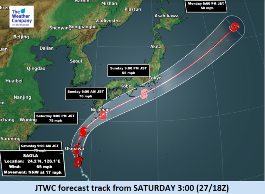
Late season Tropical Storm Saola is today located in the south of Japan and is tracking north-westward. It is expected to swing north east over the next few days.
Saola has already brought rain and strong winds to Okinawa.
Saola is expected to develop for the next 3 days and winds near the centre will become stronger with the chance on Sunday it may grow to a typhoon for a short time.
However NASA has confirmed today the storm isn’t likely to grow much more with wind shear already affecting the tropical low.
Storm Highlights:
- Tropical storm SAOLA (27W) is currently located at 24.0N 128.1E to the south of Okinawa with maximum sustained (1-minute) wind speed 100km/h with gusts 130km/h at 3:00 JST (27/18z).
- SAOLA will track northward almost along the islands from Okinawa to Tanegashima in the next 24 hours, slightly strengthened to 120km/h (typhoon strength).
- Thereafter the track will sharply curve eastward along the southern coast of Japan.
- Damaging winds up to 110km/h are expected in islands from Okinawa to Tanegashima on Saturday.
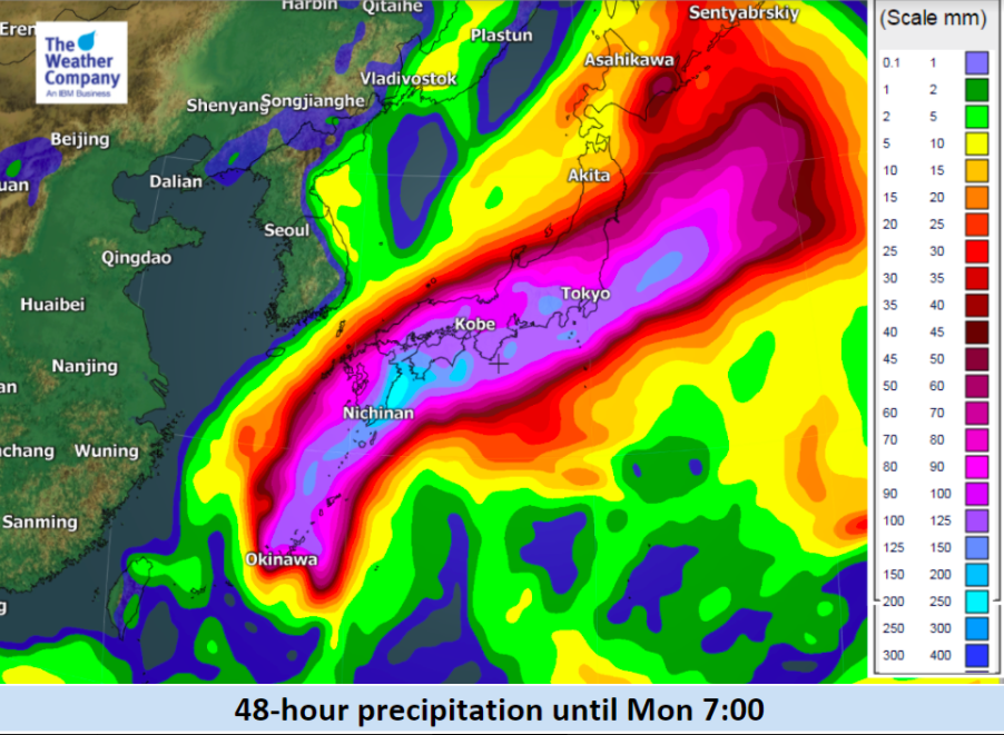
- 24-hour rain accumulation is expected to reach 250mm in Amami islands and some areas in Miyazaki and Kagoshima prefecture where southeasterly wind is blocked by mountain ridges. Heavier rainfall enhanced by topography is also possible in Yakushima island.
- Rain accumulation on Sunday will be 100-150 mm from southern Shikoku, Kinki to Tokai and Kanto region.
- Note that the forecast confidence is low about the speed of eastward movement of Saola, leaving the uncertainty in the exact timing of heaviest precipitation in southern Japan.

– WeatherWatch.co.nz with The Weather Company
Latest Video

Slow go for northern low & southern cold
For the next few days low pressure will crawl over the upper North Island, driving in rain as far south…
Related Articles

ClimateWatch: JUNE outlook as El Niño continues to build
June has kicked off in NEUTRAL again as far as El Niño is concerned, but it is expected to form…

ClimateWatch: May outlook & El Niño discussion
Everyone is talking about El Niño so in this month’s update we discuss when it may be forming and what…
Tropical Cyclone VAIANU: Fiji then NZ
*Published Tuesday AM* Fiji is being affected today by offshore Severe Tropical Cyclone Vaianu and NZ has the chance of…

