
> From the WeatherWatch archives
#YASI — Intense Tropical Cyclone Yasi is nearing landfall with severe gales now blasting the Queensland coastline along with huge seas – timed with high tide.
A wall of water that is both a storm surge combined with towering 12 metre high waves (high enough to swamp a Boeing 737) is moving into the coastline and will take with it beachfront homes and buildings and cause catastrophic flooding far worse than most rainstorms could create.
Along with the storm surge there will hurricane force winds, stronger than those of Hurricane Katrina when she made landfall near New Orleans in 2005.
Cyclone Yasi is 10 times bigger than the devastating Cyclone Larry which was also a category 5 cyclone that hit in March 2006.
We have extensive information below from the Bureau of Meteorology including the latest maps and some popular links which include Video, Audio and Streaming webcams.
We will continue to provide frequent updates until it makes landfall.
– WeatherWatch.co.nz
Latest Details about Severe Cyclone Yasi at 8pm EST (10pm NZT) – Issued by BoM
- Centre located near…… 17.2 degrees South 147.3 degrees East
- Location accuracy…….. within 20 kilometres
- Recent movement………. towards the west southwest at 26 kilometres per hour
- Wind gusts near centre… 285 kilometres per hour
- Severity category…….. 5
- Central pressure……… 930 hectoPascals
Latest Storm Warning from the Bureau of Meteorolgy
TROPICAL CYCLONE ADVICE NUMBER 20
Issued at 8:07pm EST on Wednesday the 2nd of February 2011
A Cyclone WARNING is current for coastal and island communities from Cape Flattery to Sarina , extending west across the tropical interior to the Northern Territory border.
At 8:00 pm EST Severe Tropical Cyclone Yasi, Category 5 was estimated to be 165 kilometres east southeast of Cairns and 135 kilometres east northeast of Innisfail and moving west southwest at 26 kilometres per hour.
THE VERY DESTRUCTIVE CORE OF CYCLONE YASI WILL CROSS THE COAST NEAR INNISFAIL
CLOSE TO MIDNIGHT, WITH A DANGEROUS STORM TIDE AND BATTERING WAVES SOUTH OF THE
CYCLONE CENTRE.
Tropical Cyclone Yasi, CATEGORY 5, will continue to move in a west-southwesterly direction and is expected to cross the coast near Innisfail close to midnight.
Coastal residents between Cairns and Ayr are specifically warned of an EXTREMELY DANGEROUS SEA LEVEL RISE [i.e. storm tide] as the cyclone approaches, crosses the coast and moves inland.
Higher than normal tides will exceed the high water mark with damaging waves and flooding in low lying areas in remaining warning areas to the south of Ayr.
VERY DESTRUCTIVE winds with gusts up to 290 km/h are expected to develop between Cairns and Ingham during the next few hours as the cyclone approaches. These VERY DESTRUCTIVE winds will extend inland to the nearby ranges including the Atherton Tablelands.
Due to the large size of the cyclone, people in the path of the VERY DESTRUCTIVE WINDS are likely to experience these conditions for about 3 to 4 hours.
DESTRUCTIVE winds with gusts in excess of 125 km/h between Cape Tribulation and
Ayr are expected to spread inland overnight.
DAMAGING WINDS with gusts to 90 km/hr are occurring in remaining coastal areas between Cape Flattery and Sarina, and are forecast to spread inland and west to Mt Isa during Thursday.
Winds are forecast to gradually ease about the east coast during Thursday morning as the cyclone moves inland.
FLOODING RAINS will develop from Cooktown to Sarina tonight and gradually extend inland.
Latest Tracking as Hurricane Force winds move closer
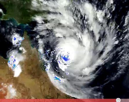
Latest Satellite Map (infrared – click to animate)

Other links you might find interesting:
Audio: Cairns Police Audio Feed
VIDEO: Philip Duncan talks about Cyclone Yasi

Updated Animation: Monster cyclone roars towards Queensland
Streaming Webcams: Watch Cyclone Yasi LIVE here
.jpg)
Follow WeatherWatch.co.nz on FACEBOOK – Just click here to “Like” us!
Latest Video

Wintry change coming for SI and lower NI
Some wet weather, along with a drop in temperatures, will move into the lower South Island later on Sunday and…
Related Articles

ClimateWatch: JUNE outlook as El Niño continues to build
June has kicked off in NEUTRAL again as far as El Niño is concerned, but it is expected to form…

ClimateWatch: May outlook & El Niño discussion
Everyone is talking about El Niño so in this month’s update we discuss when it may be forming and what…

Wed April 29 – No video today sorry!
Apologies but due to some tech hassles with our camera (and a fairly quiet weather forecast) we don’t have an…

