InfoGraphic: The Main Weather News Highlights across NZ: Wed, Thu, Fri
12/12/2017 6:00pm

> From the WeatherWatch archives
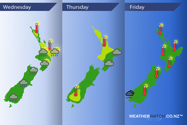
A south to southwesterly airflow lies over New Zealand today then an anticyclone muscles in over New Zealand on Thursday while a southeasterly airflow eases over the North Island. A front pushes onto the lower South Island on Friday while a ridge sits over the North Island.
Wednsesday
Showers may become heavy about the interior of both Islands this afternoon then easing in the evening.
Yellow – Temperatures reaching into the mid twenties for some upper and eastern parts of the North Island.
Thursday
Yellow – Afternoon high’s in the mid twenties for the upper North Island on Thursday, also inland Southland / parts of Central Otago.
Early drizzle clears for the eastern South Island, continuing for much of the day along the North Island’s East Coast.
Friday
A front may bring some heavy rain to Fiordland for a time on Friday, easing from later in the afternoon. Another warm day for the east of the South Island and much of the North Island, temperatures in the mid to high twenties.
– Please note, the idea behind this update is to focus on the main weather highlights, which is why not all regions are mentioned.
For specific 10 day information for your city, town, rural community or island please see the 1500 forecasts on our homepage!
– Aaron Wilkinson, WeatherWatch.co.nz
Latest Video

Cold weekend, frosts return with high pressure, then a low late next week
The subantarctic airflow spreads over NZ today/tonight and into Saturday, dropping temperatures nationwide. Snow flurries are possible today to lower…
Related Articles
Cold weekend, frosts return with high pressure, then a low late next week
The subantarctic airflow spreads over NZ today/tonight and into Saturday, dropping temperatures nationwide. Snow flurries are possible today to lower…

Wintry burst of weather: Snow, squally showers then sunshine & frosts
A polar change (another one!) arrives on Friday for the South Island and goes nationwide on Saturday, leaving NZ under…

Antarctic southerly for parts of NZ Fri & Sat
For the first time this year a southerly from off Antarctica is heading towards the South Island, followed by more…

