InfoGraphic: The Main Weather News Highlights across NZ: Wed, Thu, Fri
21/11/2017 6:00pm

> From the WeatherWatch archives
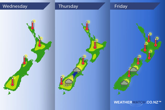
An anticyclone brings mainly settled conditions for New Zealand on Wednesday through to Friday although conditions may become unstable inland in the South Island during the afternoons.
Wednesday
Yellow – A warm day across most of New Zealand with afternoon high’s in the high teens or low twenties, reaching into the mid to high twenties for the lower South Island and some inland parts of the North Island.
Thursday
Yellow – Another warm day across much of New Zealand, especially for inland areas with high’s reaching into the low to mid twenties for most, high twenties for parts of Central Otago and the inner North Island.
Blue – Isolated heavy showers with a risk of thunderstorms for the inner South Island late afternoon / evening.
Friday
Hot once again for the upper South Island and much of the North Island on Friday, inland areas will be the warmest with temperatures reaching into the mid to late twenties for inland parts of the North Island in the afternoon. Heavy showers late afternoon / evening for inland parts of the South Island, a chance of thunderstorms also then clearing later in the day.
– Please note, the idea behind this update is to focus on the main weather highlights, which is why not all regions are mentioned.
For specific 10 day information for your city, town, rural community or island please see the 1500 forecasts on our homepage!
– Aaron Wilkinson, WeatherWatch.co.nz
Latest Video

Pockets of hit & miss heavy rain, snow moves northwards
Low pressure continues to slowly move across the upper North Island and for some that will bring the sun out,…
Related Articles
Pockets of hit & miss heavy rain, snow moves northwards
Low pressure continues to slowly move across the upper North Island and for some that will bring the sun out,…

Slow go for northern low & southern cold
For the next few days low pressure will crawl over the upper North Island, driving in rain as far south…

Slow moving low to track over northern NZ
A low pressure zone will slowly cross the North Island over the coming days, bringing hit and miss pockets of…

