InfoGraphic: The Main Weather News Highlights across NZ: Wed, Thu, Fri
7/11/2017 6:00pm

> From the WeatherWatch archives
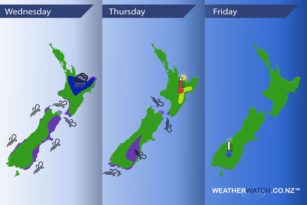
A southwestely airflow lies over New Zealand today with a cold front clearing off to the northeast of the North Island this morning. A westerly airflow on Thursday with a front moving onto the lower South Island in the evening. A weak ridge pushes in on Friday while a low becomes organised just north of the North Island.
Wednesday
Blue – Rain passing through the upper North Island may be heavy early this morning however quickly easing.
Purple – West to Southwesterly winds gusty for many coastal parts of the South Island in the morning then easing.
Thursday
Purple – West to northwesterly winds gusty about many parts of the South Island especially in the afternoon, winds strongest about coastal Southland. Northerlies through Cook Strait become gusty in the afternoon then ease later in the evening.
Yellow – High’s in the low to mid twenties for the eastern North Island in the afternoon.
Friday
Not much going on for Friday, it will be a cool morning to start for Central Otago, chance of a light frost but temperatures around 2 degrees at dawn may be more likely.
– Please note, the idea behind this update is to focus on the main weather highlights, which is why not all regions are mentioned.
For specific 10 day information for your city, town, rural community or island please see the 1500 forecasts on our homepage!
– Aaron Wilkinson, WeatherWatch.co.nz
Comments
Before you add a new comment, take note this story was published on 7 Nov 2017.
Latest Video

VIDEO: Another big low late week brings severe weather risks to NZ
Severe weather is back in the forecast later this week after we kick off July with high pressure at the…
Related Articles
VIDEO: Another big low late week brings severe weather risks to NZ
Severe weather is back in the forecast later this week after we kick off July with high pressure at the…

VIDEO: NZ 7 Day: One big low, a high, then another big low
Severe weather risks continue around NZ’s two main islands for the rest of Friday and going into Saturday, before conditions…

VIDEO: Severe weather for parts of NZ, ahead of more high pressure
A large low in the Tasman Sea will bring further heavy rain and strong winds to western and southern parts…


Add new comment