InfoGraphic: The Main Weather News Highlights across NZ: Wed, Thu. Fri
26/09/2017 6:00pm

> From the WeatherWatch archives
A slack pressure gradient brings light winds and potentially unstable conditions today for some regions. A ridge gradually weakens for the South Island and lower North Island on Thursday while low pressure further north weakens also. Overnight a front pushes in from the west.
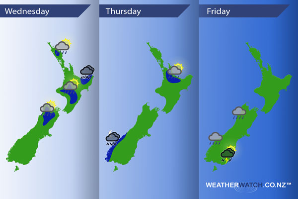
Wednesday
Blue – Afternoon heating may lead to isolated heavy showers about the upper South Island and some inland North Island areas then easing in the evening, perhaps even the chance of a thunderstorm.
Heavy rain about eastern Bay Of Plenty / East Cape eases this afternoon.
Thursday
Blue – In the afternoon / evening isolated heavy showers develop about the Waikato / Bay Of Plenty then easing later on. Chance of a thunderstorm within these showers also.
Overnight as a front pushes onto the South Island heavy rain moves into South Westland.
Friday
Rain, possibly heavy at times on Friday along the West Coast then easing in the evening. An afternoon southwest change pushes into Otago bringing heavy showers, thunderstorms possible too especially near the coast.
– Please note, the idea behind this update is to focus on the main weather highlights, which is why not all regions are mentioned.
For specific 10 day information for your city, town, rural community or island please see the 1500 forecasts on our homepage!
– Aaron Wilkinson, WeatherWatch.co.nz
Latest Video

Wintry weather coming: Snow, rain, wind & sunshine
A cold front is moving into NZ from Friday to Sunday with low pressure developing west of NZ and then…
Related Articles

Polar airflow + northern low = pockets of heavy rain & snow
A colder change is coming – and so too is a large low which will develop and grow over northern…
Wintry weather coming: Snow, rain, wind & sunshine
A cold front is moving into NZ from Friday to Sunday with low pressure developing west of NZ and then…

ClimateWatch: JULY outlook & what El Niño means for NZ
El Niño is officially here and still getting stronger in the months ahead, but it’s harder to notice its effects…

