InfoGraphic: The Main Weather News Highlights across NZ: Wed, Thu, Fri
22/08/2017 7:00pm

> From the WeatherWatch archives
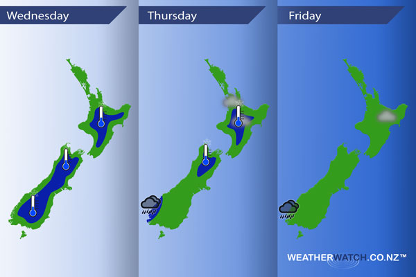
An anticyclone covers most of New Zealand today, a light northwesterly airflow within this high covers the South Island. Still mainly anticyclonic on Thursday, leading to more mainly settled weather however a front brushes the far south of the country. This front stays in place on Friday, northerly quarter winds for most regions.
Wednesday
Blue – Another frosty start this morning for many inland areas.
Thursday
Blue – Still a bit chilly to start the day inland for some but not looking as bad as Wednesday morning (today). Watch for a risk of fog in the morning from Auckland through to the Central North Island.
Some heavy about Fiordland from afternoon.
Friday
Chance patch of fog about northeastern parts of the North Island in the morning then breaking away. Also, areas of heavy rain may continue to move into Fiordland at times.
– Please note, the idea behind this update is to focus on the main weather highlights, which is why not all regions are mentioned.
For specific 10 day information for your city, town, rural community or island please see the 1500 forecasts on our homepage!
– Aaron Wilkinson, WeatherWatch.co.nz
Latest Video

Cold weekend, frosts return with high pressure, then a low late next week
The subantarctic airflow spreads over NZ today/tonight and into Saturday, dropping temperatures nationwide. Snow flurries are possible today to lower…
Related Articles
Cold weekend, frosts return with high pressure, then a low late next week
The subantarctic airflow spreads over NZ today/tonight and into Saturday, dropping temperatures nationwide. Snow flurries are possible today to lower…

Wintry burst of weather: Snow, squally showers then sunshine & frosts
A polar change (another one!) arrives on Friday for the South Island and goes nationwide on Saturday, leaving NZ under…

Antarctic southerly for parts of NZ Fri & Sat
For the first time this year a southerly from off Antarctica is heading towards the South Island, followed by more…

