InfoGraphic: The Main Weather News Highlights across NZ: Wed, Thu, Fri
23/05/2017 6:57pm

> From the WeatherWatch archives
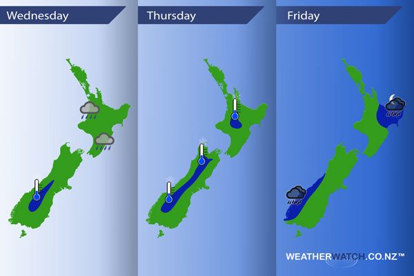
A front crosses over the North Island today, a ridge builds over the South Island then the North Island later in the day. An anticyclone moves out to the east on Thursday as a northeasterly airflow develops. A couple of fronts move in from the north and west on Friday, moving over later in the day.
Wednesday
Blue – A ridge brings a cold temperatures to some inland parts of the South Island, not a severe frost but in the region of 0 to -2 degrees celsius for the area shaded in blue below.
As a front moves over the North Island expect a few showers today, there is a chance of an isolated heavy fall this afternoon for areas between Auckland and Taranaki, also Hawkes Bay and the Wairarapa in the east.
Thursday
Blue – A cold start for inland areas, it is winter after all. Not a big frost but the potential is there for some areas in blue below to get down to the 0 to -2 degree celsius range.
Friday
Blue – Rain about South Westland may be heavy at times.
Some heavy rain may affect northeastern parts of the North Island later in the evening / overnight as a low pressure systems moves in.
– Please note, the idea behind this update is to focus on the main weather highlights, which is why not all regions are mentioned.
For specific 10 day information for your city, town, rural community or island please see the 1500 forecasts on our homepage!
– Aaron Wilkinson, WeatherWatch.co.nz
Latest Video

Cold weekend, frosts return with high pressure, then a low late next week
The subantarctic airflow spreads over NZ today/tonight and into Saturday, dropping temperatures nationwide. Snow flurries are possible today to lower…
Related Articles
Cold weekend, frosts return with high pressure, then a low late next week
The subantarctic airflow spreads over NZ today/tonight and into Saturday, dropping temperatures nationwide. Snow flurries are possible today to lower…

Wintry burst of weather: Snow, squally showers then sunshine & frosts
A polar change (another one!) arrives on Friday for the South Island and goes nationwide on Saturday, leaving NZ under…

Antarctic southerly for parts of NZ Fri & Sat
For the first time this year a southerly from off Antarctica is heading towards the South Island, followed by more…

