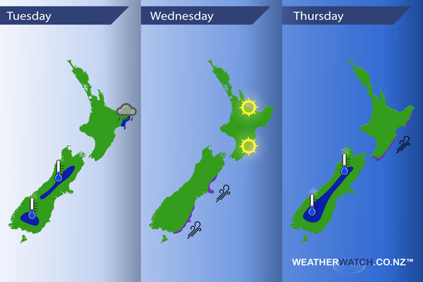
InfoGraphic: The Main Weather News Highlights across NZ: Tue, Wed, Thu
17/04/2017 7:00pm

> From the WeatherWatch archives
A large anticyclone sits in the Tasman Sea today through to Thursday while a ridge stretches out over New Zealand. A front moving around the outside of this high moves up the eastern side of the country during Wednesday and Thursday.
Tuesday
Blue – A few showers this morning about Gisborne may be heavy then easing.
A cold start about some inland parts of the South Island, not quite a frost but temperatures starting out in the early single figure range.
Wednesday
Purple – Southwesterlies freshen along the east coast of the South Island during the day, winds generally in the brisk range about coastal fringes as a change moves through perhaps becoming strong at times.
A mainly sunny day for the Bay Of Plenty and Hawkes Bay / Wairarapa.
Thursday
Blue – A cold start about the inner South Island, perhaps just reaching down to 0 degrees in some spots.
Purple – Southwesterly winds freshen along the east coast of the North Island during the day, only just on the coastal fringes.
– Please note, the idea behind this update is to focus on the main weather highlights, which is why not all regions are mentioned.
For specific 10 day information for your city, town, rural community or island please see the 1500 forecasts on our homepage!
– Aaron Wilkinson, WeatherWatch.co.nz
Latest Video

Temperature changes for some regions ahead of heavy West Coast rain
A nor-wester is about to kick in and it’s coming from out of Australia, boosting temperatures in some regions going…
Related Articles
Temperature changes for some regions ahead of heavy West Coast rain
A nor-wester is about to kick in and it’s coming from out of Australia, boosting temperatures in some regions going…

NZ 7 day forecast: Showers, temp changes and heavy West Coast rain
NZ has a fairly messy forecast over the next 7 days, but the main feature will be heavy rain on…

Cold fronts continue, wind & rain for some Fri/Sat
Wet weather is moving over the North Island today, while the South Island has drier skies – ahead of another…

