InfoGraphic: The Main Weather News Highlights across NZ: Tue, Wed, Thu
20/11/2017 6:00pm

> From the WeatherWatch archives
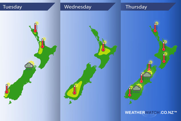
A large anticyclone in the Tasman Sea stretches out a ridge over New Zealand today bringing mainly settled weather. Eastern regions may experience some cloud and a shower or drizzle patch however. This anticyclone brings mainly settled conditions for New Zealand on Wednesday and Thursday although conditions may become unstable inland in the South Island.
Tuesday
Yellow – Afternoon high’s in the mid twenties for western parts of the North Island and lower southwestern South Island.
A few isolated showers may develop about the northwestern corner of the South Island late afternoon.
Wednesday
Yellow – A warm day across most of New Zealand with afternoon high’s in the high teens or low twenties, reaching into the mid to high twenties for the lower South Island and some inland parts of the North Island.
Thursday
Another warm day across much of New Zealand, especially for inland areas with high’s reaching into the low to mid twenties for most, high twenties for parts of Central Otago and the inner North Island. Isolated heavy showers with a risk of thunderstorms for the inner South Island late afternoon / evening.
– Please note, the idea behind this update is to focus on the main weather highlights, which is why not all regions are mentioned.
For specific 10 day information for your city, town, rural community or island please see the 1500 forecasts on our homepage!
– Aaron Wilkinson, WeatherWatch.co.nz
Latest Video

Wintry weather coming: Snow, rain, wind & sunshine
A cold front is moving into NZ from Friday to Sunday with low pressure developing west of NZ and then…
Related Articles

Polar airflow + northern low = pockets of heavy rain & snow
A colder change is coming – and so too is a large low which will develop and grow over northern…
Wintry weather coming: Snow, rain, wind & sunshine
A cold front is moving into NZ from Friday to Sunday with low pressure developing west of NZ and then…

ClimateWatch: JULY outlook & what El Niño means for NZ
El Niño is officially here and still getting stronger in the months ahead, but it’s harder to notice its effects…

