InfoGraphic: The Main Weather News Highlights across NZ: Tue, Wed, Thu
21/08/2017 7:00pm

> From the WeatherWatch archives
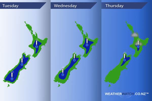
An anticyclone brings mainly settled weather to the South Island today, a southerly airflow over the North Island ease during the day. Anticyclonic conditions for much of Wednesday although a northwesterly airflow develops about the lower South Island from afternoon. Still mainly anticyclonic on Thursday, leading to more mainly settled weather.
Tuesday
Blue – A frosty start to the day for both islands, especially the South Island.
Wednesday
Blue – Another frosty start to the day, this time especially about the North Island and upper South Island.
Thursday
Still a bit chilly to start the day inland for some but not looking as bad as Tuesday and Wednesday. Watch for a risk of fog in the morning from Auckland through to the Central North Island.
Beyond the potential for frosts and fog in the coming days another main standout is the fact we are finally having some settled, dry weather. Many regions can expect plenty of sun this week also although as usualy with highs it isn’t exactly straight forward, there will be niggly bits of cloud about for some. Check out our centre forecasts on the homepage for info on your town / city or region.
– Please note, the idea behind this update is to focus on the main weather highlights, which is why not all regions are mentioned.
For specific 10 day information for your city, town, rural community or island please see the 1500 forecasts on our homepage!
– Aaron Wilkinson, WeatherWatch.co.nz
Latest Video

Wintry weather coming: Snow, rain, wind & sunshine
A cold front is moving into NZ from Friday to Sunday with low pressure developing west of NZ and then…
Related Articles

Polar airflow + northern low = pockets of heavy rain & snow
A colder change is coming – and so too is a large low which will develop and grow over northern…
Wintry weather coming: Snow, rain, wind & sunshine
A cold front is moving into NZ from Friday to Sunday with low pressure developing west of NZ and then…

ClimateWatch: JULY outlook & what El Niño means for NZ
El Niño is officially here and still getting stronger in the months ahead, but it’s harder to notice its effects…

