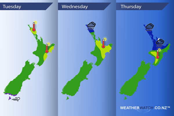
InfoGraphic: The main Weather News Highlights across NZ: Tue, Wed, Thu
13/02/2017 6:00pm

> From the WeatherWatch archives
A front weakens over the upper North Island during today while another front over the upper South Island weakens during the day also, both fronts are quite slow moving. A front lingers over Northland on Wednesday, reinvigorating later on with some heavy rain possible meanwhile the South Island sits under a ridge of high pressure. A front slowly slinks southwards over the upper North Island during Thursday while the rest of the country has high pressure.
Tuesday
Purple – Westerlies becoming strong about coastal Southland in the afternoon, winds may gust to gale at times.
Yellow – High’s in the mid to late 20’s for the east of the North Island and about Northland.
Wednesday
Blue – Rain about Northland may become heavy for some spots late afternoon / evening.
Yellow – Temperatures reaching into the mid 20’s for the North Island as marked below.
Thursday
Blue – Rain, possibly heavy about Northland then easing later in the afternoon. Rain slowly slinks southwards during the afternoon and evening into the Waikato and Bay Of Plenty with the chance of a heavy fall.
Yellow – High’s in the mid to late 20’s in the afternoon for the southwestern corner of the North Island.
– Please note, the idea behind this update is to focus on the main weather highlights, which is why not all regions are mentioned.
For specific 10 day information for your city, town, rural community or island please see the 1500 forecasts on our homepage!
– Aaron Wilkinson, WeatherWatch.co.nz
Latest Video

Temperature changes for some regions ahead of heavy West Coast rain
A nor-wester is about to kick in and it’s coming from out of Australia, boosting temperatures in some regions going…
Related Articles
Temperature changes for some regions ahead of heavy West Coast rain
A nor-wester is about to kick in and it’s coming from out of Australia, boosting temperatures in some regions going…

NZ 7 day forecast: Showers, temp changes and heavy West Coast rain
NZ has a fairly messy forecast over the next 7 days, but the main feature will be heavy rain on…

Cold fronts continue, wind & rain for some Fri/Sat
Wet weather is moving over the North Island today, while the South Island has drier skies – ahead of another…

