InfoGraphic: The Main Weather News Highlights across NZ: Tue, Wed, Thu
27/06/2017 4:50am

> From the WeatherWatch archives
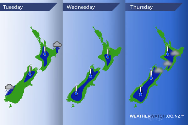
Weak high pressure for much of New Zealand over the next 3 days, a front weakens about the lower South Island today meanwhile another weak feature hangs around the Bay Of Plenty / Waikato regions over Wednesday and Thursday.
Wednesday
Blue – Further frosty conditions continue however eastern coastal parts of the South Island escape this time around due to cloud cover. Lows may get down to -2 to -4 degrees about the inner South Island, 0 to -2 about the inner North Island.
Thursday
Blue – Frosts continue for inland areas of both islands. Perhaps a touch of fog to start the day also about the eastern North Island (mainly inland) and also the top of the South Island.
– Please note, the idea behind this update is to focus on the main weather highlights, which is why not all regions are mentioned.
For specific 10 day information for your city, town, rural community or island please see the 1500 forecasts on our homepage!
– Aaron Wilkinson, WeatherWatch.co.nz
Latest Video

Wintry weather coming: Snow, rain, wind & sunshine
A cold front is moving into NZ from Friday to Sunday with low pressure developing west of NZ and then…
Related Articles

Polar airflow + northern low = pockets of heavy rain & snow
A colder change is coming – and so too is a large low which will develop and grow over northern…
Wintry weather coming: Snow, rain, wind & sunshine
A cold front is moving into NZ from Friday to Sunday with low pressure developing west of NZ and then…

ClimateWatch: JULY outlook & what El Niño means for NZ
El Niño is officially here and still getting stronger in the months ahead, but it’s harder to notice its effects…

