InfoGraphic: The Main Weather News Highlights across NZ: Tue, Wed, Thu
12/06/2017 7:00pm

> From the WeatherWatch archives
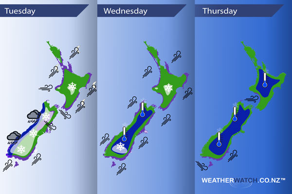
A strong westerly airflow lies over New Zealand today, changing to the southwest about the lower South Island from late morning as a front moves in. This front zooms northwards to reach the upper North Island overnight. A strong southwesterly airflow eases later on Wednesday. Westerlies build over the South Island on Thursday before a moderate front moves onto the lower South Island late afternoon, west to southwest winds continue over the North Island.
Tuesday
Blue – Heavy rain moves into Fiordland this morning then moves into North Westland this afternoon, rain eases to showers in the evening.
Purple – We have a brisk westerly airflow for much of the country, strong about parts of Central New Zealand. A strong southwest change moves onto the lower South Island this morning then moves northwards reaching the upper North Island overnight. This southwest change brings strong winds to many coastal areas with a risk of gales.
White – As the cold change mentioned above moves onto the lower South Island in the morning with it brings a risk of snow. While many areas below are shaded in, Canterbury and Marlborough in particular will only get a few flurries to the levels mentioned next in this statement then clearing away. Southland and Otago sees snow lower to 400 or perhaps even 300m at times during the afternoon / evening, easing towards dawn on Wednesday. Canterbury sees brief flurries lower to 500m overnight, Marlborough to 600m then clearing away for most although remaining out on Banks Peninsula. Some parts of the Central North Island sees flurries down to 700m by dawn on Wednesday.
Wednesday
Purple – Strong to gale south to southwesterly winds ease later in the day for most coastal parts of New Zealand, not easing about the eastern North Island till dawn on Thursday. Winds will be strongest about coastal parts of the eastern North Island late afternoon / evening.
White – Remaining morning snow flurries about parts of Otago and coastal Canterbury to 400 or perhaps even 300m clearing away. Snow will not be heavy although combined with very strong winds, outer parts of Banks Peninsula will be in for a rough day. Snow flurries about the Central North Island to 600m clearing around midday.
Thursday
Blue – A frosty start for most regions away from the coast, temperatures starting out at -3 to 0 degrees celsius for the inner North Island. Temperatures may dip to -4 degrees for isolated parts of the inner South Island (Pukaki / Twizel comes to mind).
Purple – Northwesterlies build about coastal parts of the lower South Island in the morning, winds may gust to gale through Foveaux strait then changing southwest early afternoon where winds could be strong especially about coastal Otago.
Gusty westerlies build about some central parts of New Zealand in the afternoon, easing overnight.
– Please note, the idea behind this update is to focus on the main weather highlights, which is why not all regions are mentioned.
For specific 10 day information for your city, town, rural community or island please see the 1500 forecasts on our homepage!
– Aaron Wilkinson, WeatherWatch.co.nz
Latest Video

Wintry weather coming: Snow, rain, wind & sunshine
A cold front is moving into NZ from Friday to Sunday with low pressure developing west of NZ and then…
Related Articles

Polar airflow + northern low = pockets of heavy rain & snow
A colder change is coming – and so too is a large low which will develop and grow over northern…
Wintry weather coming: Snow, rain, wind & sunshine
A cold front is moving into NZ from Friday to Sunday with low pressure developing west of NZ and then…

ClimateWatch: JULY outlook & what El Niño means for NZ
El Niño is officially here and still getting stronger in the months ahead, but it’s harder to notice its effects…

