InfoGraphic: The main Weather News Highlights across NZ: Thu, Fri, Sat
15/03/2017 6:00pm

> From the WeatherWatch archives
A large anticyclone lies over the country today then northwesterlies develop over the South Island on Friday with a ridge further north, a front moves onto the lower South Island later in the evening. This front moves northwards over the country on Saturday however it weakens quite fast due to another incoming high.
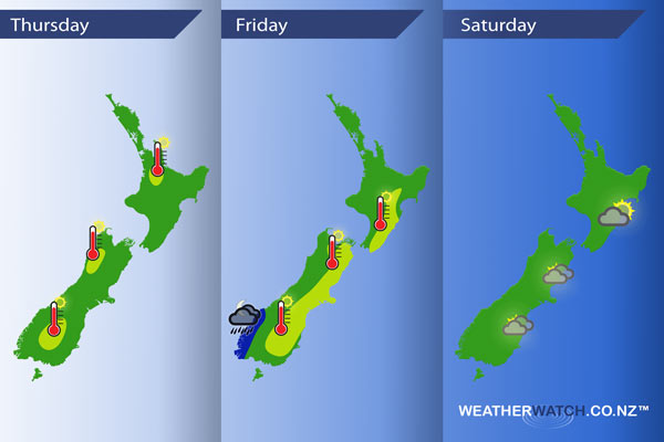
Thursday
Yellow – Temperatures reaching into the mid 20’s for the areas in yellow below, perhaps even into the high 20’s about Central Otago.
Friday
Blue – Rain about Fiordland in the evening and for a time overnight may be heavy.
Yellow – Afternoon high’s in the mid to high 20’s for the east of New Zealand due to a northwesterly airflow.
Saturday
As a front moves northwards over New Zealand on Saturday it weakens a fair amount, it will bring cloudy areas to the east of the South Island from morning, perhaps even a drizzle patch or two. A sunny start for the east of the North Island then cloud develops in the afternoon as southerlies freshen, evening drizzle also.
Sunnier for the west of the North Island on Saturday, rain or showers clears in the morning for the west of the South Island then sun breaks through from afternoon.
– Please note, the idea behind this update is to focus on the main weather highlights, which is why not all regions are mentioned.
For specific 10 day information for your city, town, rural community or island please see the 1500 forecasts on our homepage!
– Aaron Wilkinson, WeatherWatch.co.nz
Latest Video

Cold weekend, frosts return with high pressure, then a low late next week
The subantarctic airflow spreads over NZ today/tonight and into Saturday, dropping temperatures nationwide. Snow flurries are possible today to lower…
Related Articles
Cold weekend, frosts return with high pressure, then a low late next week
The subantarctic airflow spreads over NZ today/tonight and into Saturday, dropping temperatures nationwide. Snow flurries are possible today to lower…

Wintry burst of weather: Snow, squally showers then sunshine & frosts
A polar change (another one!) arrives on Friday for the South Island and goes nationwide on Saturday, leaving NZ under…

Antarctic southerly for parts of NZ Fri & Sat
For the first time this year a southerly from off Antarctica is heading towards the South Island, followed by more…

