InfoGraphic: The Main Weather News Highlights across NZ: Thu, Fri, Sat
19/07/2017 7:00pm

> From the WeatherWatch archives
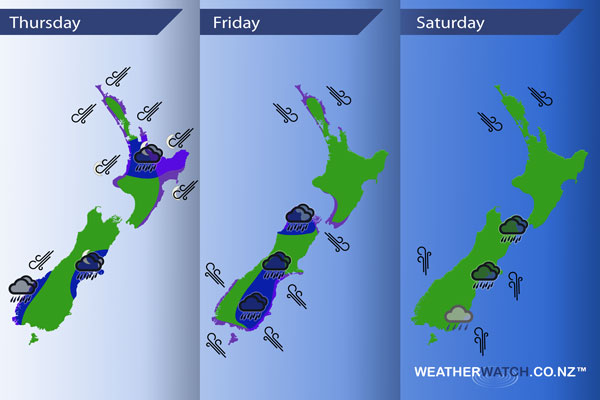
A northeasterly airflow strengthens over New Zealand today with a large deep low gradually moving towards the western side of the country during the day, the low centre moves to become situated over the upper South Island overnight. Strong southeasterlies for the lower South Island on Friday, northwesterlies further north. Southerlies about the South Island spread northwards during the afternoon / evening on Saturday.
Thursday
Blue – A deep low forms moving into position west of the South Island. Hooked into this low is a front which moves in from the west delivering heavy rain about the upper North Island in the evening then easing overnight. Rain about Fiordland may be heavy then easing from afternoon. The Canterbury regions sees heavy rain towards dawn on Friday.
Purple – North to northeasterly winds preceding this front are quite strong with gales likely about coastal areas especially about northeastern parts of the North Island.
Friday
A low deepens further and sits over the upper South Island on Friday, winds around the low are gusty and strong, more so about the eastern South Island south of Banks Peninsula where severe gales may develop about the coast. Expect some heavy rain also about the eastern South Island Banks Peninsula southwards.
Snow keeps above 800m for the South Island, lowering to 600m in the evening about Southland.
Saturday
Rain for the eastern South Island for much of the day, more persistent in the northeast then gradually easing. Gusty southerlies for the South Island, strong to gale northwesterlies during the day about Northland.
– Please note, the idea behind this update is to focus on the main weather highlights, which is why not all regions are mentioned.
For specific 10 day information for your city, town, rural community or island please see the 1500 forecasts on our homepage!
– Aaron Wilkinson, WeatherWatch.co.nz
Comments
Latest Video

Wintry weather coming: Snow, rain, wind & sunshine
A cold front is moving into NZ from Friday to Sunday with low pressure developing west of NZ and then…
Related Articles

Polar airflow + northern low = pockets of heavy rain & snow
A colder change is coming – and so too is a large low which will develop and grow over northern…
Wintry weather coming: Snow, rain, wind & sunshine
A cold front is moving into NZ from Friday to Sunday with low pressure developing west of NZ and then…

ClimateWatch: JULY outlook & what El Niño means for NZ
El Niño is officially here and still getting stronger in the months ahead, but it’s harder to notice its effects…


Guest on 19/07/2017 10:56pm
How strong are the winds likley to get around rangiora area please
WW Forecast Team on 19/07/2017 11:00pm
Mostly calm according to the latest guidance (big lows are very hard to fine tune sometimes in NZ due to our geography). At this stage you may get a gusty SW change on Saturday PM but probably not even reaching gale force let alone severe. Winds fade again on Sunday in Rangiora.
Cheers
WW
Guest on 19/07/2017 11:27pm
Thank u so much I find you to be the most accurate and detailed weather forecasters, great for someone like me who has a bad weather fear, you don’t hype it all up like most others xx